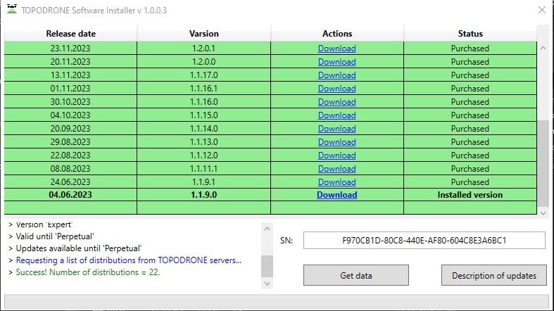
# Downloading installation files
# Changes in licensing of the software "TOPODRONE Post Processing"
TOPODRONE announces significant changes to the licensing system for its TOPODRONE Post Processing software from 01.06.2023. As part of these changes, licenses will now be issued as activation keys, which will significantly simplify the process of obtaining and activating the software.
With the introduction of the new system, customers will no longer be required to use their personal account to activate the program. TOPODRONE Post Processing is now activated by entering the key in the appropriate field on the screen. This activation method makes the process more convenient for users, as it allows them to avoid additional steps related to account management.
However, successful activation of the software will still require access to the Internet. This is necessary to verify the validity of the entered key and to confirm the license, which ensures licensing compliance and protects the software from unauthorized use.
TOPODRONE is confident that these changes will not only improve the user experience, but will also make the activation process more intuitive and faster. We want users to be able to focus on their tasks, not the hassle of managing licenses. With the new activation system, TOPODRONE Post Processing will be easier to use and communication with the program will be more efficient.
Now all distributions are in [TOPODRONE Software Distributor](https://file.topodrone.com/TOPODRONE%20SD.exe)
# TPP v.1.5.2.1 updated 27.07.2025
If the paid technical support period ended before 27.07.2025, then this distribution will not work for the user. He will need to either pay for support or download previous distributions, the release date of which is earlier than the paid support period ended.
Get the distribution: [TOPODRONE Software Distributor](https://file.topodrone.com/TOPODRONE%20SD.exe)
**Added:** Fixed bugs, improved security, accelerated operation, added new functionality compared to the previous version.
**PPK Post Processing:**
Added support for SWIR camera.
[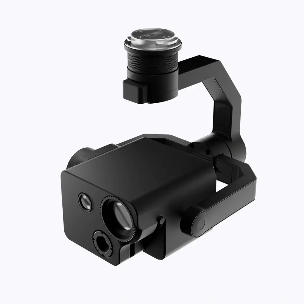](https://knowledge.topodrone.ru/uploads/images/gallery/2025-04/swir01bg.webp)
**RTK Post Processing:** The photographic centers are adjusted to the offsets from the MRK file.
**The utility "Merge RINEX files" is now available under the "PRO" license**
**[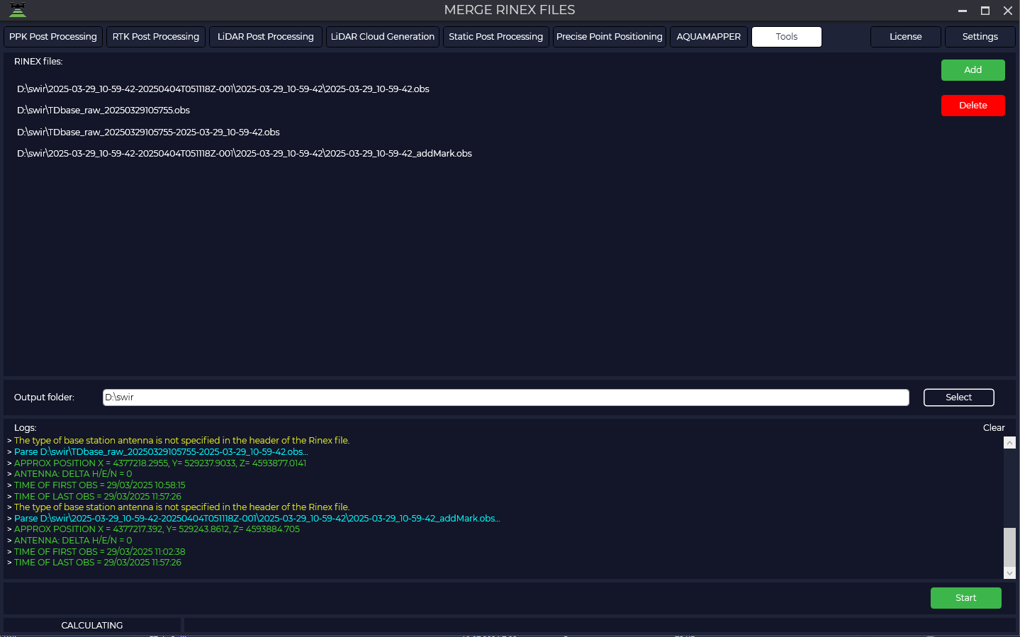](https://knowledge.topodrone.ru/uploads/images/gallery/2025-04/rinex.png)**
**The release date can now be seen on the license information page:**
[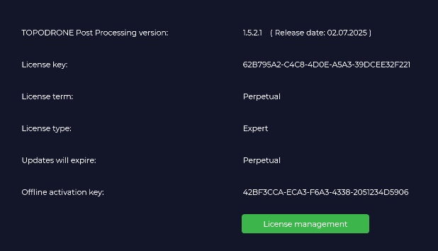](https://knowledge.topodrone.com/uploads/images/gallery/2025-07/image.png)
**Updated antenna file -> igs20\_2353.atx**
**New utility for transforming point clouds from local/wgs84 to local/wgs84 coordinate systems:**
[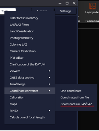](https://knowledge.topodrone.ru/uploads/images/gallery/2025-07/65uimage.png)
[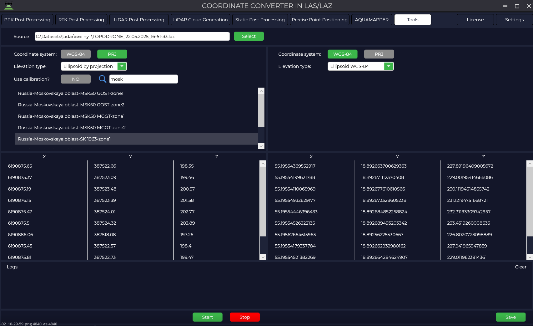](https://knowledge.topodrone.com/uploads/images/gallery/2025-07/zj8image.png)
**DJI Mavic 3 Multispectral Support:**
[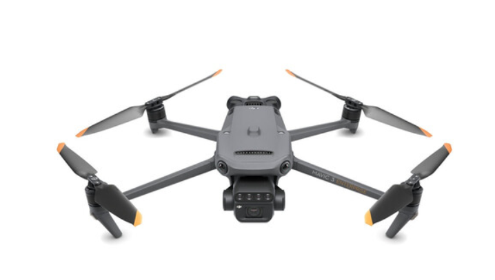](https://knowledge.topodrone.ru/uploads/images/gallery/2025-07/6plimage.png)
**PPK Post Processing/RTK Post Processing/LiDAR Post Processing:**
A log file is generated in the output folder for processing analysis or transfer to the technical support service.
[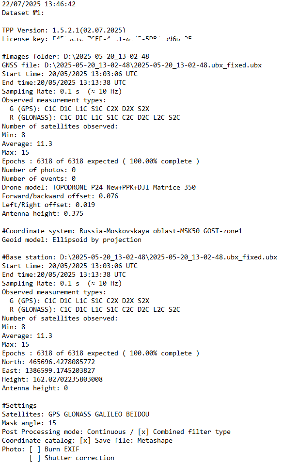](https://knowledge.topodrone.ru/uploads/images/gallery/2025-07/logs.png)
**PPK Post Processing/RTK Post Processing:**
Accelerated display of markers on maps (photography center/GNSS marks/information).
[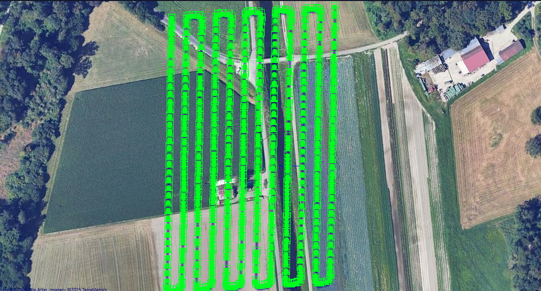](https://knowledge.topodrone.ru/uploads/images/gallery/2025-07/GI1image.png)
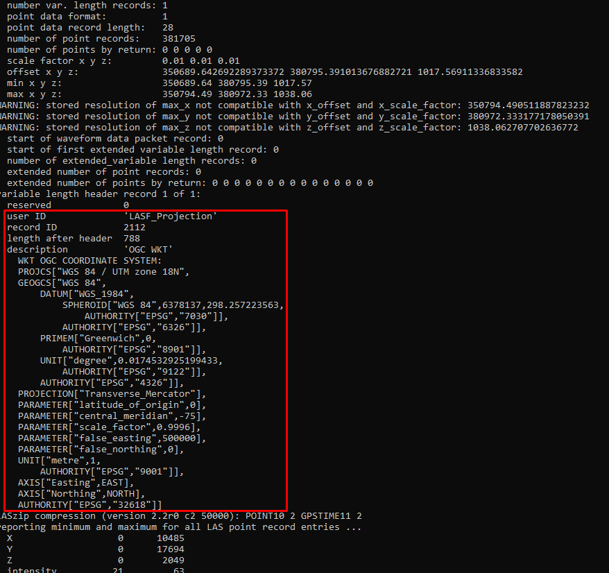
**Lidar Cloud Generation:**
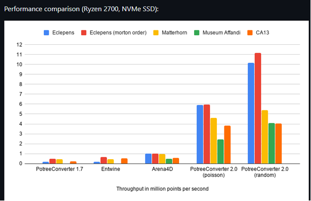
The calculation of calibration angles has been accelerated. Now the calculation time on the entire track or its part is performed equally in time. Calculated offsets are used for overflights. The lasinfo utility from the LAStools library has been integrated to check the correctness of LAS/LAZ headers. The PRJ information of the coordinate system in which the cloud is calculated is also added to the LAZ/LAS header.
[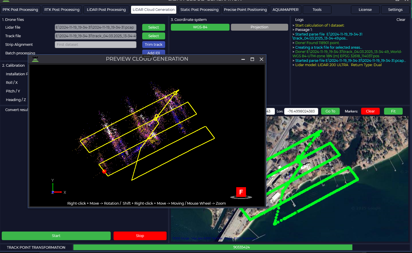](https://knowledge.topodrone.ru/uploads/images/gallery/2025-07/W66image.png)
[](https://knowledge.topodrone.com/uploads/images/gallery/2025-07/Cd8image.png)
**Общее:**
Speeded up loading of PRJ (about 6000 files) when starting the program.
[](https://knowledge.topodrone.ru/uploads/images/gallery/2025-07/sgaimage.png)
Added the ability to disable GPS grouping when calculating GNSS. Frequency trimming (L1/L2...) has been removed from the interface. All frequencies are included in the calculation.
[](https://knowledge.topodrone.ru/uploads/images/gallery/2025-07/ItVimage.png)
# TPP v.1.5.1.4 updated 07.03.2025
If the paid technical support period ended before 25.01.2025, then this distribution will not work for the user. He will need to either pay for support or download previous distributions, the release date of which is earlier than the paid support period ended.
Get the distribution: [TOPODRONE Software Distributor](https://file.topodrone.com/TOPODRONE%20SD.exe)
**Added:** Fixed bugs, improved security, accelerated operation, added new functionality compared to the previous version.
**PPK Post Processing:**
Added support for new UNICORE GNSS chips for all TOPODRONE models.
Added GNSS antenna offset presets for TOPODRONE P24 New + PPK + DJI Matrice 350.
Added automatic detection of typical offsets based on image tag data.
Implemented processing of data from TOPODRONE Q.FLY.
Antenna offset parameters are hidden from display
**RTK Post Processing:**
Implemented automatic loading of navigation files for each flight.
Fixed display of the "Plot" window in batch processing.
**LiDAR Post Processing:**
Fixed display of the "Plot" window in batch processing.
LiDAR Cloud Generation:
Added the ability to obtain point clouds along trajectories in local rectangular coordinates.
**AQUMAPPER:**
Improved automation of processes by implementing a filter for automatic removal of points with zero depth values.Added division of the TOPODRONE AQUAMAPPER Next dual-frequency sensor by frequencies in the \*.LAZ format 200 kHz - 2 reflections, 450 kHz - 1 reflection.Added rounding of rectangular coordinates, heights and depths to three decimal places in \*.CSV files.Reworked algorithm, allowing more accurate calculation of temperature for each measurement.
# TPP v.1.5.1.3 updated 25.01.2025
If the paid technical support period ended before 25.01.2025, then this distribution will not work for the user. He will need to either pay for support or download previous distributions, the release date of which is earlier than the paid support period ended.
Get the distribution: [TOPODRONE Software Distributor](https://file.topodrone.com/TOPODRONE%20SD.exe)
**Added:** Bugs fixed, security improved, work accelerated, new functionality added in comparison with the previous version.
**Fixed:** LPP, PPK, RTK - The "Coordinate System", "Logs" and "Map" windows in the specified modules became the same size.
**Fixed:** RTK - When loading data into PPK Post Processing, the globe button for viewing the "Plot" window is not displayed, including during batch processing.
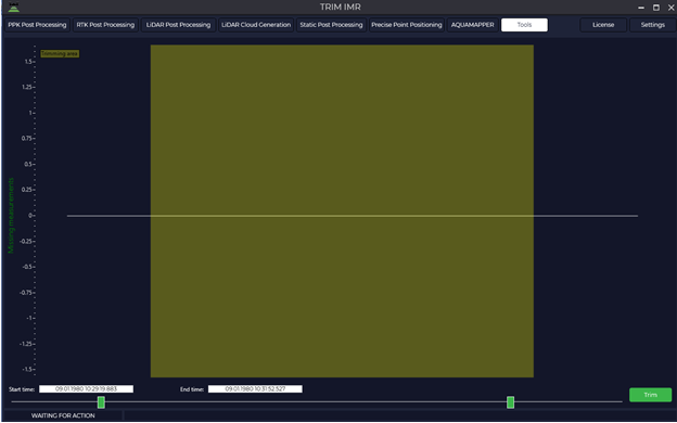
**Added:** LPP - Automatic check for missing IMU measurements with a trimming warning with the following text: "IMR file has time gaps, use the "IMR Trim" tool."
**Added:** PPK, RTK, LPP - Automatic check for rover and base station recording times. If the base station operating time does NOT include the rover operating time, then the message is displayed: "The base station operating time does not match the rover operating time.", if the base station operating time includes the rover operating time, then standard processing is performed. In the case of batch processing, all rover files are checked with the base station file.
# TPP v.1.5.1.2 updated 28.12.2024
If the paid technical support period ended before 12/28/2024, then this distribution will not work for the user. He will need to either pay for support or download previous distributions, the release date of which was earlier than the paid support period ended.
Get the distribution: [TOPODRONE Software Distributor](https://file.topodrone.com/TOPODRONE%20SD.exe)
**Added:** Bugs fixed, security improved, work accelerated, new functionality added in comparison with the previous version.
**Added:** License information window, with the ability to launch the license management manager from the TPP interface.
**Added:** AQUAMAPPER: Support for dual-frequency echo sounder (200 kHz + 450 kHz). The low-frequency signal has a greater penetration depth, but poor detail, and vice versa, the high-frequency signal is more susceptible to scattering in water, but provides higher clarity and detail. Using a dual-frequency echo sounder increases the depth of signal penetration and the ability to separate weak reflected signals to obtain greater detail.
**Added:** PPK: Automatically converts shutter response time to a single format, which avoids doubling of marks. Finds gaps in shutter response marks and adds them to the stream through approximation.
**Fixed:** RTK: Adjusted the parameters of the "Dynamic" function. Previously, some data sets could not be calculated correctly.
**Added:** Updated RTKlib library (j->k)
**Added:** LCG Calculation of calibration angles A new algorithm has been developed with the introduction of a multiplier depending on the speed of movement (Accelerating the time to find corrections).
**Added:** AQUAMAPPER displays the trajectory in the Plot window
# TPP v.1.4.5.0 updated 12.11.2024
If the paid technical support period ended before 11.12.2024, then this distribution will not work for the user. He will need to either pay for support or download previous distributions, the release date of which is earlier than the paid support period ended.
Get the distribution: [TOPODRONE Software Distributor](https://file.topodrone.com/TOPODRONE%20SD.exe)
\+ Fixed bugs, improved security, increased speed and accuracy of calculations compared to the previous version.
\+ **Added:** Support for GNSS receivers from Unicore (PPK module).
[](https://knowledge.topodrone.com/uploads/images/gallery/2024-11/unicore-logo.png)
**+ Fixed:** In the RTK module bin is correctly converted to obs and nav.
**+ Fixed:** Improved generation of georeferencing file for photogrammetry.
**+ Added:** The program is updated via the TOPODRONE distribution servers.
[](https://knowledge.topodrone.com/uploads/images/gallery/2024-11/tsd.jpg)
# TPP v.1.4.4.4 updated 04.11.2024
If paid support expired before 04.11.2024, this TPP version will not work for a user. It is necessary to either pay for support or download previous version distributive, the release date of which is earlier than the expiration date of paid support.
Get the distribution: [TOPODRONE Software Distributor](https://file.topodrone.com/TOPODRONE%20SD.exe)
\+ **Fixed:** correct conversion of \*.bin to RINEX in RTK Post Processing module
**+ Added: LiDAR Post Processing**: Rinex.24O is converted to Rinex.obs before sending to IE.
**+ Added:** Camera calibration utility (Fix radial and tangential distortion in photos):
\+ **Added:** PPK Post Processing module: additionally creates shutter time file (For LAZ coloring utility)
\+ **Added:** LAZ coloring utility for photos
# TPP v.1.4.4.2 updated 02.10.2024
If paid support expired before 02.10.2024, this TPP version will not work for a user. It is necessary to either pay for support or download previous version distributive, the release date of which is earlier than the expiration date of paid support.
Get the distribution: [TOPODRONE Software Distributor](https://file.topodrone.com/TOPODRONE%20SD.exe)
\+ **Fixed:** AQUAMAPPER GNSS time has a day transition or batch post-processing of datasets taken over several weeks.
\+ **Fixed:** SPP single vector/SPP network equalization/PPP: Updated links for downloading ephemeris from the server (University of California, San Diego \[UCSD\]), because NASA server does not have ephemeris for every day.
\+ **Fixed:** LCG: During calculation of angles can make a large number of passes. Limit the number of passes = 10.
\+ **Added:** “Clear logs” button in all modules.
\+ **Added:** PRJ: Moved to the Server. Now they can be loades the same way as Geoids.
\+ **Fixed:** PPK/RTK configuration files.
# TPP v.1.4.4.1 updated 10.09.2024
If paid support expired before 10.09.2024, this TPP version will not work for a user. It is necessary to either pay for support or download previous version distributive, the release date of which is earlier than the expiration date of paid support.
Get the distribution: [TOPODRONE Software Distributor](https://file.topodrone.com/TOPODRONE%20SD.exe)
**+ Added:** when generating several clouds from the same trajectory, the trajectory is replaced in the Local Coordinate System (LSC). If 3 different clouds needs to be generated from one pcap file and from one trajectory after LiDAR Post Ptocessing module, TPP will generate 3 clouds and one trajectory for the last generated cloud. The trajectory in LSC have an additional prefix \_CHMSS.
**+ Fixed:** during the LiDAR calibration angles calculation TPP can make a large number of passes. The algorithm for finding calibration angles is supplemented with automatic calculation of the scaling factor of the headings (depending on the velocity of motion). There should not be a large number of passes
**+** **Fixed:** PPK/RTK modules: drone speeds in output catalogs are now taken from event.pos. Previously they were read from pos.stat, which in some situations were zeros.
**+ Fixed:** During processing of data from cameras without navigation centers of photos, after processing of trajectories the view was reset to coordinates 0;0. For all these cameras now the view on the screen does not change.
**+ Added:** LPP: it is now possible to enter the base station phase center coordinates in LSC, including taking into account the geoid model.
**+ Added:** AQUAMAPPER: In batch processing, simultaneous loading of UBX data is now available.
**+ Fixed** PPK: after TOPODRONE PT61 post-processing data if another data from any other camera that does not have a thermal imaging sensor post processing starts, a previews of the thermal imaging images are still generated.
\+ **Added:** IMR Viewer: the vibration graph starts on 0
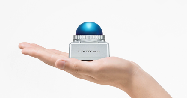
\+ **Fixed:** Adjusted parsing of lidar file MID-360
# TPP v.1.4.4.0 updated 13.08.2024
If paid support expired before 13.09.2024, this TOPODRONE Post Processing version will not work for a user. It is necessary to either pay for support or download previous version distributive, the release date of which is earlier than the expiration date of paid support.
Get the distribution: [TOPODRONE Software Distributor](https://file.topodrone.com/TOPODRONE%20SD.exe)
\+ **Fixed:** Datum parameters refinement (we wrote our own code completely. Before third-party library used).
\+ **Fixed:** Track stitching does not work correctly, the header is not correct.
\+ **Added:** “Open catalog” button to calibration added.
\+ **Added:** a “Slope Treatment” checkbox has been added to Land Classification.
\+ **Fixed:** When exporting photo center catalog for Agisoft Metashape/3DSurvey, correct column formation is done.
\+ **Fixed:** previews for thermal imager TOPODRONE PT61 were not generated correctly. There are different sensor sizes: 320 and 640 pixels.
\+ **Fixed:** when the number of TOPODRONE PT61 photos and tags is different, the manual matching window does not exit and as a result the catalog of photo centers is not formed.
\+ **Added:** the IMR viewer displays vibration graphs.
\+ **Fixed:** the “Mark Time Correction” field in the photogrammetry settings returned.
# TPP v.1.4.3.0 updated 30.07.2024
If paid support expired before 30.07.2024, this TOPODRONE Post Processing version will not work for a user. It is necessary to either pay for support or download previous version distributive, the release date of which is earlier than the expiration date of paid support.
Get the distribution: [TOPODRONE Software Distributor](https://file.topodrone.com/TOPODRONE%20SD.exe)
+ **Added:** processing settings of the AQUAMAPPER module are displayed in the UI. Added roll/pitch/bottom of water body infographics.
+ **Added:** forest inventory utility
[](https://knowledge.topodrone.com/uploads/images/gallery/2024-10/uTcimage.png)
[](https://knowledge.topodrone.com/uploads/images/gallery/2024-10/wqfimage.png)
# TPP v.1.4.2.0 updated 20.06.2024
If paid support expired before 20.06.2024, this TOPODRONE Post Processing version will not work for a user. It is necessary to either pay for support or download previous version distributive, the release date of which is earlier than the expiration date of paid support.
Get the distribution: [TOPODRONE Software Distributor](https://file.topodrone.com/TOPODRONE%20SD.exe)
\+ **Added:** multispectral + infrared camera support.
[](https://knowledge.topodrone.com/uploads/images/gallery/2024-10/n2Nimage.png)
\+ **Updated:** built-in viewer updated 1.7->2.1.
[](https://knowledge.topodrone.com/uploads/images/gallery/2024-10/Jryimage.png)
# TPP v.1.3.3.4 updated 23.04.2024
If paid support expired before 23.04.2024, this TOPODRONE Post Processing version will not work for a user. It is necessary to either pay for support or download previous version distributive, the release date of which is earlier than the expiration date of paid support.
Get the distribution: [TOPODRONE Software Distributor](https://file.topodrone.com/TOPODRONE%20SD.exe)
**+ Added:** utility for trimming IMR file without GNSS. Used to trim an IMR file containing measurement omissions.
[](https://knowledge.topodrone.com/uploads/images/gallery/2024-10/94Bimage.png)
# TPP v.1.3.3.0 updated 05.04.2024
If paid support expired before 05.04.2024, this TOPODRONE Post Processing version will not work for a user. It is necessary to either pay for support or download previous version distributive, the release date of which is earlier than the expiration date of paid support.
Get the distribution: [TOPODRONE Software Distributor](https://file.topodrone.com/TOPODRONE%20SD.exe)
**+ Added:** New algorithm for calculating calibration angles of lidar installation.
**+ Fixed:** length trimming works correctly for Hesai lidars.
**+ Added:** At group calculation of high-precision track 10 times less track points are displayed on maps (the program froze during rendering).
**+ Added:** In TopoSLAM, the return of the cloud to the track is accomplished by calibration.
# TPP v.1.3.2.2 updated 17.03.2024
If paid support expired before 10.10.2024, this TOPODRONE Post Processing version will not work for a user. It is necessary to either pay for support or download previous version distributive, the release date of which is earlier than the expiration date of paid support.
Get the distribution: [TOPODRONE Software Distributor](https://file.topodrone.com/TOPODRONE%20SD.exe)
\+ **Added:** AQAMAPPER module integrated
\+ **Added:** LiDAR Calibration angles are now calculated and applied on a per-gal basis. It is used when specifying track inclination angles.
+ **Added:** WinPcap and .NET Core 3.1 Desktop Runtime are installed automatically.
# TPP v.1.2.0.1 updated 23.11.2023
If paid support expired before 10.10.2024, this TOPODRONE Post Processing version will not work for a user. It is necessary to either pay for support or download previous version distributive, the release date of which is earlier than the expiration date of paid support.
Get the distribution: [TOPODRONE Software Distributor](https://file.topodrone.com/TOPODRONE%20SD.exe)
**+ Added:** switch in the settings to standard/expert modes. Expert mode allows the user to specify the IMU and lidar model. Standard mode performs automatic equipment detection.
# TPP v.1.2.0.0 updated 20.11.2023
If paid support expired before 20.11.2023, this TOPODRONE Post Processing version will not work for a user. It is necessary to either pay for support or download previous version distributive, the release date of which is earlier than the expiration date of paid support.
Get the distribution: [TOPODRONE Software Distributor](https://file.topodrone.com/TOPODRONE%20SD.exe)
**+ Added:** Type of lidar survey is determined automatically (Aeral/Terrestrial)
**+ Added:** LiDAR firing direction is determined automatically (Forward/Backward)
**+ Added:** alternative calculation of track coordinates (algorithm of complex processing of GNSS angular positioning system information).
# TPP v.1.1.17.0 updated 13.11.2023
If paid support expired before 13.11.2024, this TOPODRONE Post Processing version will not work for a user. It is necessary to either pay for support or download previous version distributive, the release date of which is earlier than the expiration date of paid support.
Get the distribution: [TOPODRONE Software Distributor](https://file.topodrone.com/TOPODRONE%20SD.exe)
**+ Added:** Static Post Processing: automatic addition of coordinates from GNSS files
**+ Added:** Lidar Cloud Generation: automatic UTM projection selection (if user has not specified a projection)
# TPP v.1.1.16.1 updated 1.11.2023
If paid support expired before 01.11.2023, this TOPODRONE Post Processing version will not work for a user. It is necessary to either pay for support or download previous version distributive, the release date of which is earlier than the expiration date of paid support.
Get the distribution: [TOPODRONE Software Distributor](https://file.topodrone.com/TOPODRONE%20SD.exe)
\+ **Added:** combined Kalman filter enabled by default, improves accuracy of GNSS calculations (in PPK/SPPP/PPP modules).
# TPP v.1.1.16.0 updated 30.10.2023
If paid support expired before 10.10.2024, this TOPODRONE Post Processing version will not work for a user. It is necessary to either pay for support or download previous version distributive, the release date of which is earlier than the expiration date of paid support.
Get the distribution: [TOPODRONE Software Distributor](https://file.topodrone.com/TOPODRONE%20SD.exe)
**+ Added:** new algorithm for calibration angles calculation (used ICP for finding angles).
**+ Added:** MID-360 support
[](https://knowledge.topodrone.com/uploads/images/gallery/2024-10/snBimage.png)
# TPP v.1.1.15.0 updated 04.10.2023
If paid support expired before 04.10.2023, this TOPODRONE Post Processing version will not work for a user. It is necessary to either pay for support or download previous version distributive, the release date of which is earlier than the expiration date of paid support.
Get the distribution: [TOPODRONE Software Distributor](https://file.topodrone.com/TOPODRONE%20SD.exe)
**+ Added:** “Datum Refinement” utility
**+ Updated:** antenna directory for PPK, RTK modules
# TPP v.1.1.14.0 updated 20.09.2023
If paid support expired before 20.09.2023, this TOPODRONE Post Processing version will not work for a user. It is necessary to either pay for support or download previous version distributive, the release date of which is earlier than the expiration date of paid support.
Get the distribution: [TOPODRONE Software Distributor](https://file.topodrone.com/TOPODRONE%20SD.exe)
**+ Added:** lidar rotation option relative to IMU (roll/pitch/heading)
**+ Added:** PRJ Editor utility allowing to correct PRJ parameters.
# TPP v.1.1.13.0 updated 29.08.2023
If paid support expired before 29.08.2023, this TOPODRONE Post Processing version will not work for a user. It is necessary to either pay for support or download previous version distributive, the release date of which is earlier than the expiration date of paid support.
Get the distribution: [TOPODRONE Software Distributor](https://file.topodrone.com/TOPODRONE%20SD.exe)
**+ Added:** automated download of geoids from TOPODRONE server (199 geoids). Now geoids are not included in the distribution (reducing the size of the distribution), but are downloaded by users as needed.
**+ Added:** orthophoto generation module (Photogrammetry)
# TPP v.1.1.12.0 updated 22.08.2023
If paid support expired before 22.08.2023, this TOPODRONE Post Processing version will not work for a user. It is necessary to either pay for support or download previous version distributive, the release date of which is earlier than the expiration date of paid support.
Get the distribution: [TOPODRONE Software Distributor](https://file.topodrone.com/TOPODRONE%20SD.exe)
**+ Added:** new version of high-precision track calculation with support for current TOPODRONE equipment is integrated
**+ Added:** filters for quality improvement: SOR and NOISE.
**+ Updated:** LAS/LAZ library (support for 1.3/1.4 formats)
**+ Added:** a utility to automatically “terrain” classify
# TPP v.1.1.11.1 updated 08.08.2023
If paid support expired before 08.08.2023, this TOPODRONE Post Processing version will not work for a user. It is necessary to either pay for support or download previous version distributive, the release date of which is earlier than the expiration date of paid support.
Get the distribution: [TOPODRONE Software Distributor](https://file.topodrone.com/TOPODRONE%20SD.exe)
**+ Added:** HESAI lidars use calibration angles for installation
# TPP v.1.1.9.1 updated 24.06.2023
If paid support expired before 24.06.2023, this TOPODRONE Post Processing version will not work for a user. It is necessary to either pay for support or download previous version distributive, the release date of which is earlier than the expiration date of paid support.
Get the distribution: [TOPODRONE Software Distributor](https://file.topodrone.com/TOPODRONE%20SD.exe)
**+ Added:** New PRJ filtering. Progressive full-text search is used. The search result is displayed line by line by full PRJ path.
# TPP v.1.1.9.0 updated 04.06.2023
If paid support expired before 24.06.2023, this TOPODRONE Post Processing version will not work for a user. It is necessary to either pay for support or download previous version distributive, the release date of which is earlier than the expiration date of paid support.
Get the distribution: [TOPODRONE Software Distributor](https://file.topodrone.com/TOPODRONE%20SD.exe)
**+ Added:** Satellite filtering utility accelerated by 50 times
**+ Added:** A “ruler” for measuring distances has been added to all maps. You need to click twice on the map and the distance between these points will be written in the logs (in feet or meters depending on the “Feet” checkbox state).
**+ Added:** A new TOPOSLAM algorithm consisting of three stages has been added. At the first stage, the clouds are sequentially overlapped by generation time. The second stage is the mutual overlap of the clouds closest in distance. The third stage, using calibration, returns the position of the matched clouds to the track.