# RTK Post Processing

This module allows automatic processing of GNSS measurements from many aircraft, including DJI Phantom 4 RTK, DJI Matrice 300 RTK, DJI Mavic 3 Enterprise + RTK, Autel Evo II Dual RTK. To perform processing in this module, perform the following procedure:

1. <span style="font-size: 12.0pt; line-height: 115%; font-family: 'Times New Roman',serif;">Start the TOPODRONE Post Processing program and go to the tab RTK Post Processing.</span>[![RTK Post Processing_1.jpg](https://knowledge.topodrone.com/uploads/images/gallery/2024-10/scaled-1680-/rtk-post-processing-1.jpg)](https://knowledge.topodrone.com/uploads/images/gallery/2024-10/rtk-post-processing-1.jpg)
2. Select the folder with the data collected during the flight. This folder should contain the following files: all photos without renaming or deleting, \*.bin, \*.obs, \*.nav, and \*.MRK. A folder with processed results will be automatically created, which can be modified if necessary.  
    [![RTK Post Processing_2.jpg](https://knowledge.topodrone.com/uploads/images/gallery/2024-10/scaled-1680-/rtk-post-processing-2.jpg)](https://knowledge.topodrone.com/uploads/images/gallery/2024-10/rtk-post-processing-2.jpg)
    
    <span style="mso-no-proof: yes;"> </span>
3. Select the \*.nav file from the drone.  
    [![RTK Post Processing_3.jpg](https://knowledge.topodrone.com/uploads/images/gallery/2024-10/scaled-1680-/rtk-post-processing-3.jpg)](https://knowledge.topodrone.com/uploads/images/gallery/2024-10/rtk-post-processing-3.jpg)
    
    <span style="mso-no-proof: yes;"> </span>
4. Select the file from the base station (\*.ubx, \*.obs, \*.rnx, \*.o). For \*.rnx and \*.ubx files, it will automatically start the conversion process to \*.obs format.  
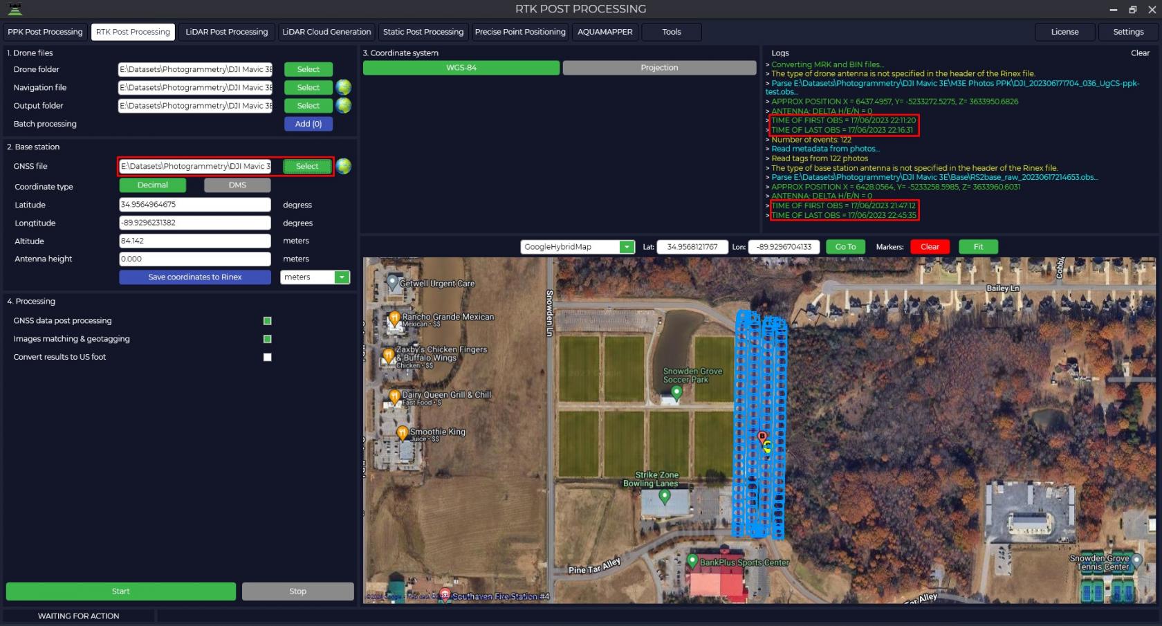
    <p class="callout info">The "Logs" window displays information about actions performed by the program, it is necessary to pay attention to the time of file recording from the rover and from the base station. The base station file must overlap the rover files.</p>
    
    <span style="font-size: 12.0pt; line-height: 115%; font-family: 'Times New Roman',serif;">[![RTK Post Processing_4.jpg](https://knowledge.topodrone.com/uploads/images/gallery/2024-10/scaled-1680-/rtk-post-processing-4.jpg)](https://knowledge.topodrone.com/uploads/images/gallery/2024-10/rtk-post-processing-4.jpg)</span><span style="mso-no-proof: yes;"> </span>The program will automatically load base station coordinates and base antenna height from the Rinex file, taking into account that it was entered during measurement.
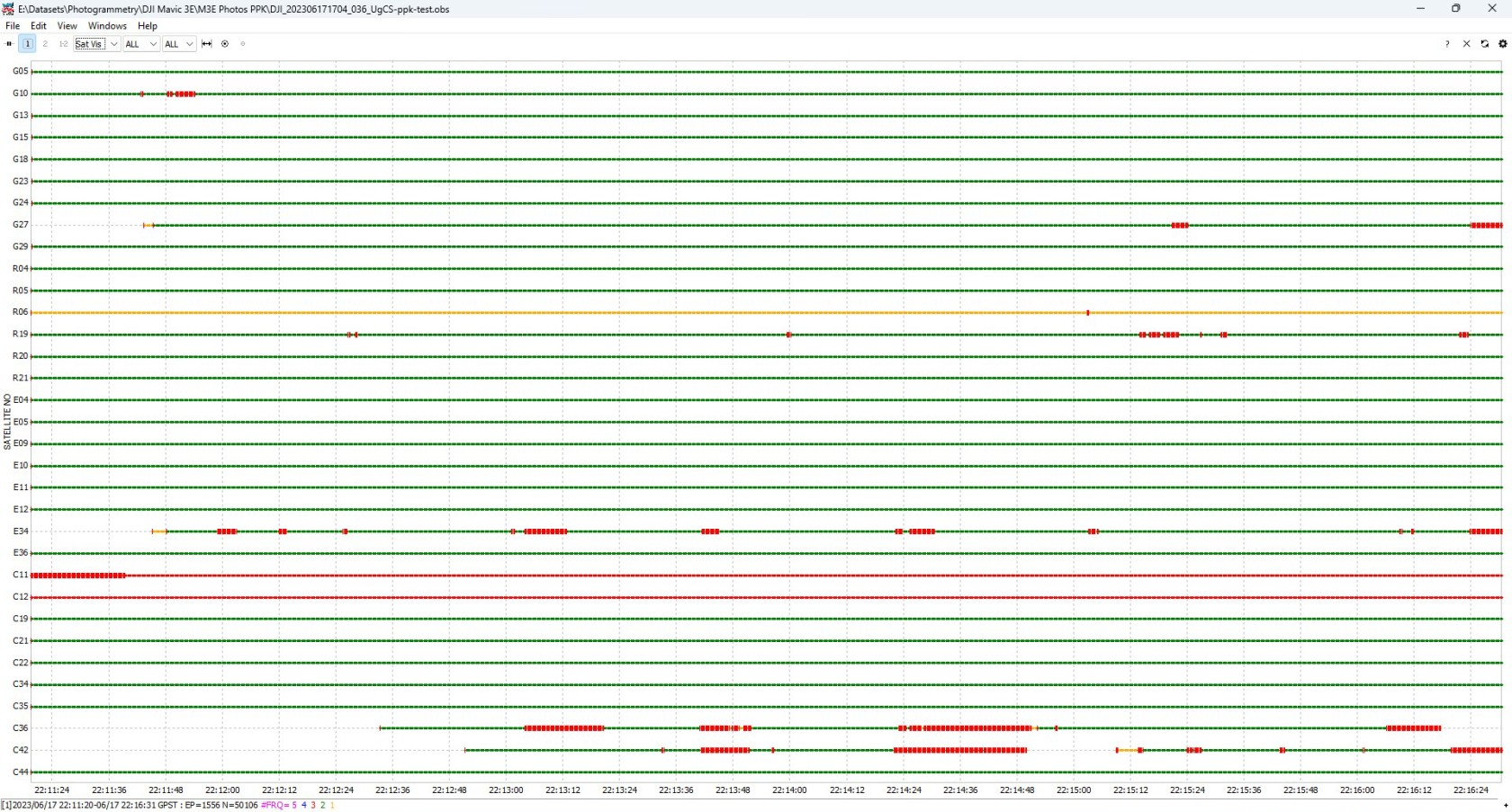
5. By pressing the [![embedded-image-fhqpququ.png](https://knowledge.topodrone.com/uploads/images/gallery/2024-11/scaled-1680-/embedded-image-fhqpququ.png)](https://knowledge.topodrone.com/uploads/images/gallery/2024-11/embedded-image-fhqpququ.png) button you can analyze the quality of the data. For <span class="aNeGP0gI0B9AV8JaHPyH" data-src-align="0:5">more</span> <span class="aNeGP0gI0B9AV8JaHPyH" data-src-align="6:8">information</span> <span class="aNeGP0gI0B9AV8JaHPyH" data-src-align="15:1">about</span> <span class="aNeGP0gI0B9AV8JaHPyH" data-src-align="34:6">data</span> <span class="aNeGP0gI0B9AV8JaHPyH" data-src-align="25:8">quality</span> <span class="aNeGP0gI0B9AV8JaHPyH" data-src-align="17:7">analysis</span>, <span class="aNeGP0gI0B9AV8JaHPyH" data-src-align="47:9">see</span> [<span class="aNeGP0gI0B9AV8JaHPyH" data-src-align="59:10">Appendix</span> <span class="aNeGP0gI0B9AV8JaHPyH" data-src-align="70:2">B.</span>](https://knowledge.topodrone.com/uploads/images/gallery/2024-07/ppk-3.png)  
    [![08_RTK.jpg](https://knowledge.topodrone.com/uploads/images/gallery/2024-07/scaled-1680-/08-rtk.jpg)](https://knowledge.topodrone.com/uploads/images/gallery/2024-07/08-rtk.jpg)
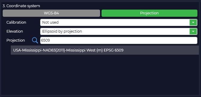
6. In case your coordinate system is different from WGS-84, you need to click the "Projection" button and select your coordinate system from the proposed list or enter the coordinate system name in the search bar. When you select the coordinate system, the conversion from WGS-84 to the selected projection will take place.
    
    <span style="mso-no-proof: yes;"> </span>  
    [![RTK Post Processing_5.jpg](https://knowledge.topodrone.com/uploads/images/gallery/2024-10/scaled-1680-/rtk-post-processing-5.jpg)](https://knowledge.topodrone.com/uploads/images/gallery/2024-10/rtk-post-processing-5.jpg)
7. If necessary, select the "Elevation Type" for your coordinate system.  
    [![RTK Post Processing_6.jpg](https://knowledge.topodrone.com/uploads/images/gallery/2024-10/scaled-1680-/rtk-post-processing-6.jpg)](https://knowledge.topodrone.com/uploads/images/gallery/2024-10/rtk-post-processing-6.jpg)
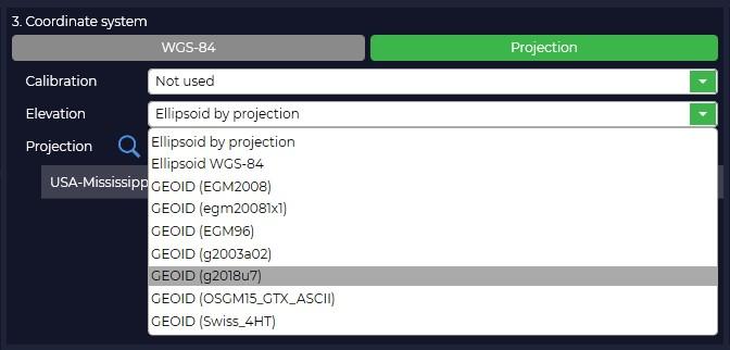
    
    If your coordinate system or geoid model is not in the list, you can add it to the TOPODRONE Post Processing program.
8. If necessary, correct the coordinates of the base station.  
    [![RTK Post Processing_7.jpg](https://knowledge.topodrone.com/uploads/images/gallery/2024-10/scaled-1680-/rtk-post-processing-7.jpg)](https://knowledge.topodrone.com/uploads/images/gallery/2024-10/rtk-post-processing-7.jpg)
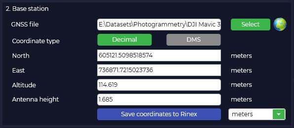
    
    <p class="callout warning">Antenna height includes the height of the milestone or tripod from the point with known coordinates to the bottom of the receiver mount and the height from the bottom of the receiver mount to the phase center</p>
9. TOPODRONE Post Processing program allows to perform batch processing of many flights from one base station within one observation session. To start batch processing it is necessary to press the "Add (0)" button, in the opened window add additional folders with other flights and press "OK"  
    [![RTK Post Processing_8.jpg](https://knowledge.topodrone.com/uploads/images/gallery/2024-10/scaled-1680-/rtk-post-processing-8.jpg)](https://knowledge.topodrone.com/uploads/images/gallery/2024-10/rtk-post-processing-8.jpg)
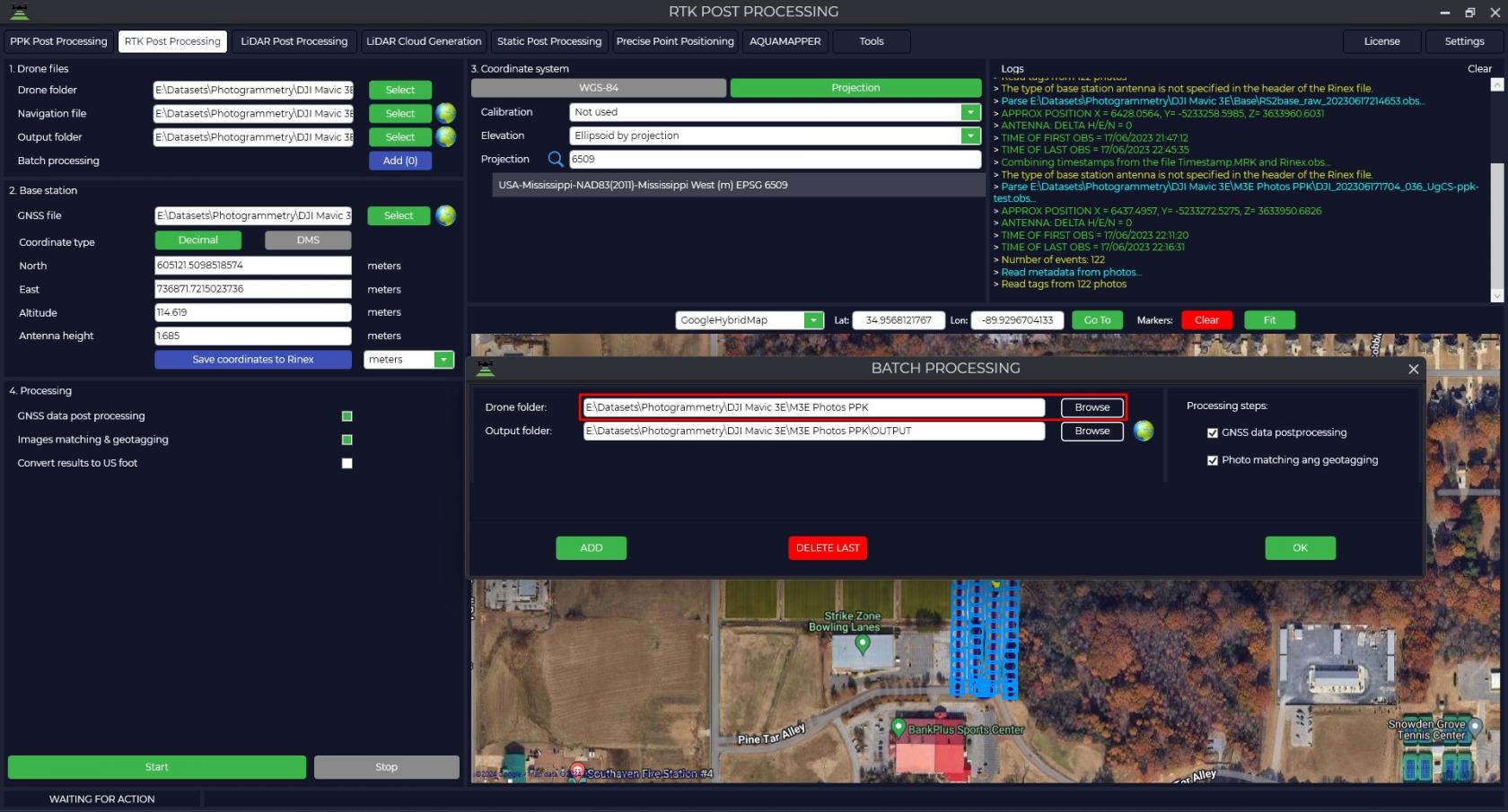
    
    <span style="mso-no-proof: yes;"> </span>
10. To start the machining process, simply press the "Start" button. Data processing takes place simultaneously in forward and reverse directions and the type of solution is displayed in the form of the letter "Q" with the addition of a number, where Q1 - fixed solution, Q2 - floating solution and Q5 - no solution.  
    [![RTK Post Processing_9.jpg](https://knowledge.topodrone.com/uploads/images/gallery/2024-10/scaled-1680-/rtk-post-processing-9.jpg)](https://knowledge.topodrone.com/uploads/images/gallery/2024-10/rtk-post-processing-9.jpg)
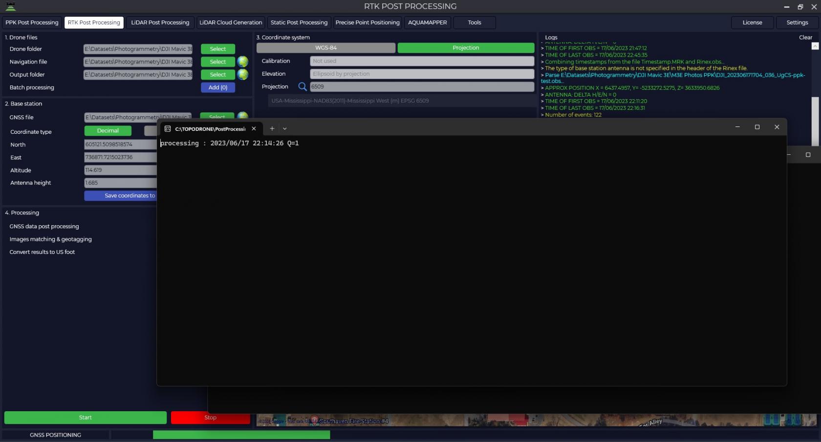
11. At the end of processing a window will be displayed, where you can see the trajectory of the rover, the number of photos, the number of marks, the number of matches and the accuracy of the obtained centers of photos, where green marks are marks obtained with a fixed solution, and yellow marks are marks obtained with a floating solution.  
    [![RTK Post Processing_10.jpg](https://knowledge.topodrone.com/uploads/images/gallery/2024-10/scaled-1680-/rtk-post-processing-10.jpg)](https://knowledge.topodrone.com/uploads/images/gallery/2024-10/rtk-post-processing-10.jpg)
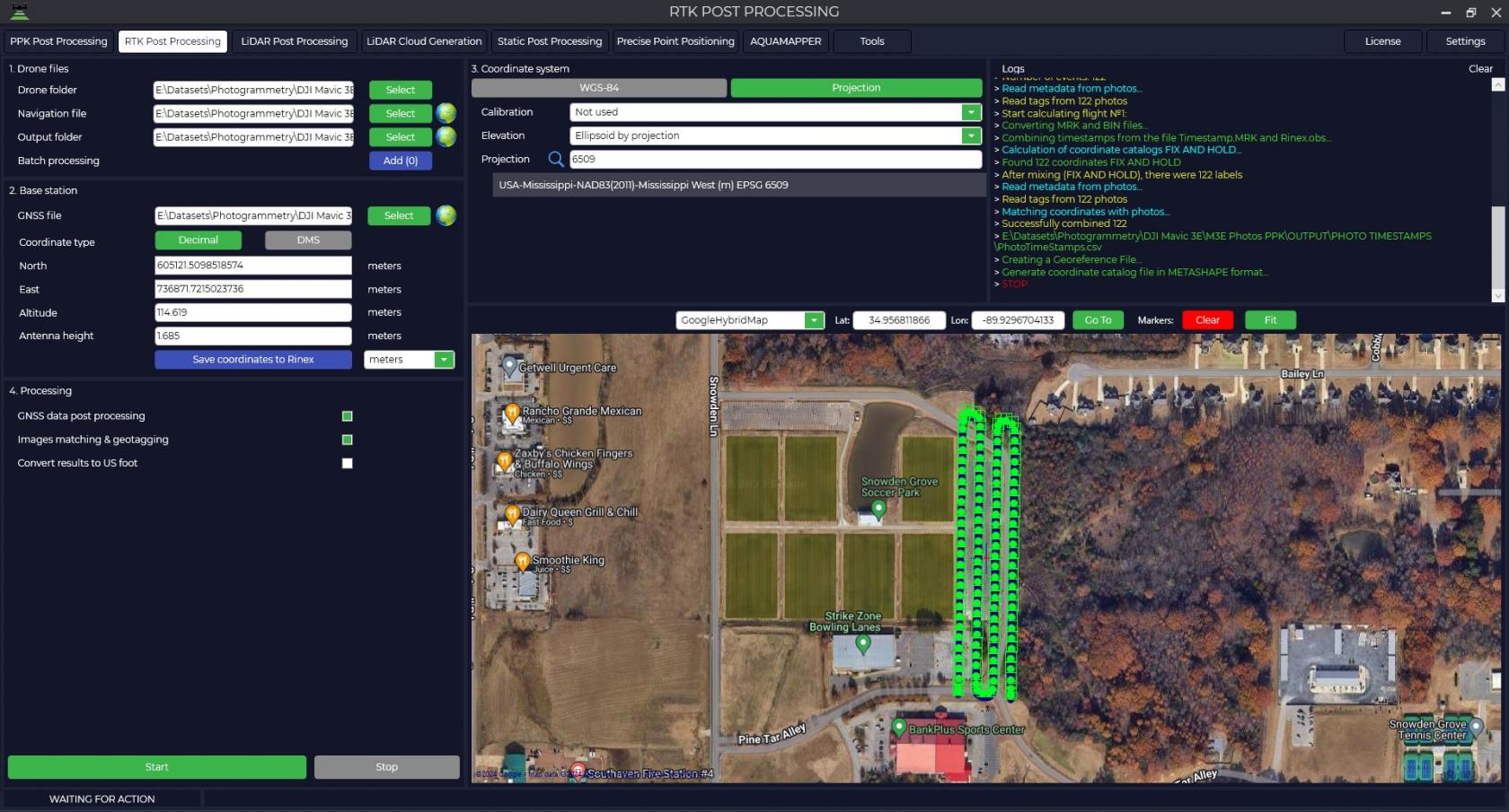
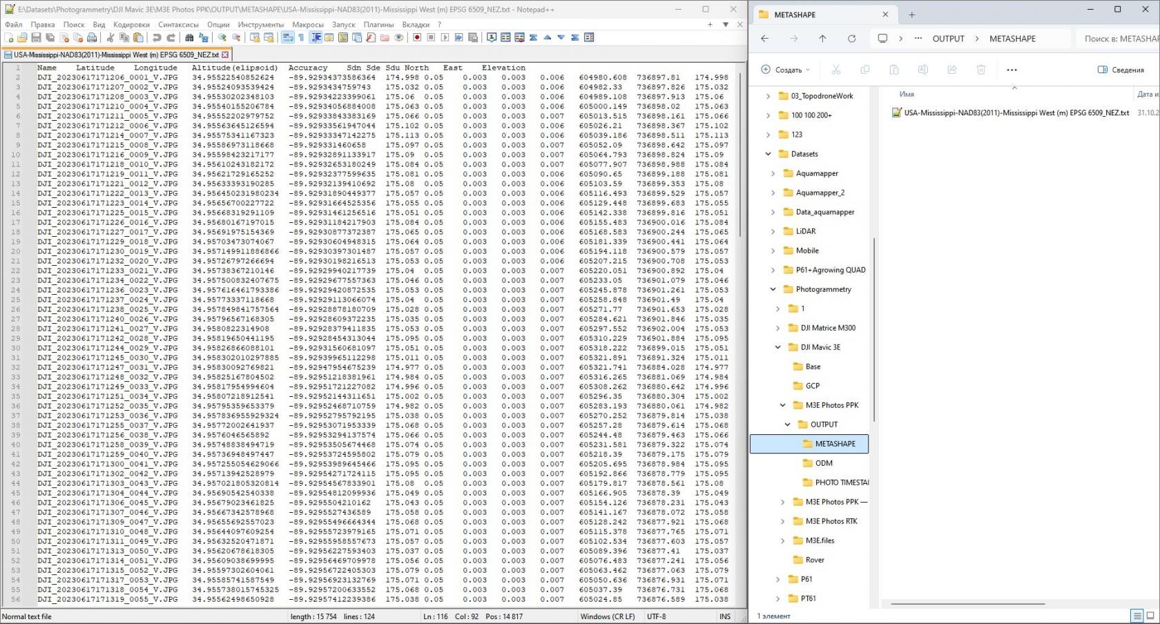
12. The output folder stores a directory of coordinates of the exact centers of photography.  
    [![RTK Post Processing_11.jpg](https://knowledge.topodrone.com/uploads/images/gallery/2024-11/scaled-1680-/rtk-post-processing-11.jpg)](https://knowledge.topodrone.com/uploads/images/gallery/2024-11/rtk-post-processing-11.jpg)