
Overlap between scans and height of scanned objects
During a flight with TOPODRONE laser scanner, the ground surface is scanned with a certain width, called “scan”. The scan width is determined by the technical characteristics of the sensor, the operating altitude of the flight, and the terrain difference.
To perform correct post-processing of data from TOPODRONE laser scanners it is necessary that neighboring scans have common overlap. It is recommended to provide at least 30% lateral overlap to adjacent scans. Insufficient overlap between scans together with significant terrain differences can create an area without any data, which will significantly reduce the quality of output materials. When choosing a specific overlap value, parameters such as maximum laser beam length, scan angle (106 degrees on LiDAR for VLS) and height of the scanned object should be taken into account. To obtain optimal results when performing VLS with TOPODRONE laser scanners, it is recommended to use the following parameters when building a mission::
|
1 |
2 |
3 |
4 |
5 |
||||||
|
LiDAR model, Maximum beam length |
Working height, m |
Scan width, m |
Distance between scan centers: % overlap, m |
Maximum height of scanned object: % overlap, m |
||||||
|
30% |
40% |
50% |
60% |
30% |
40% |
50% |
60% |
|||
|
TOPODRONE HI-RES and 100 LITE |
50 |
134 |
94 |
81 |
67 |
54 |
15 |
20 |
25 |
30 |
|
60 |
160 |
112 |
96 |
80 |
64 |
18 |
24 |
30 |
36 |
|
|
70* |
140 |
98 |
84 |
70 |
56 |
21 |
28 |
35 |
42 |
|
|
TOPODRONE 200 ULTRA |
100 |
267 |
187 |
161 |
134 |
107 |
30 |
40 |
50 |
60 |
|
110 |
292 |
205 |
176 |
146 |
117 |
33 |
44 |
55 |
66 |
|
|
120 |
320 |
224 |
192 |
160 |
128 |
36 |
48 |
60 |
72 |
|
|
130* |
260 |
182 |
156 |
130 |
104 |
39 |
52 |
65 |
78 |
|
|
140* |
280 |
196 |
168 |
140 |
112 |
42 |
56 |
70 |
84 |
|
Table 1. Dependence of the distance between scan centers on overlaps and working height.
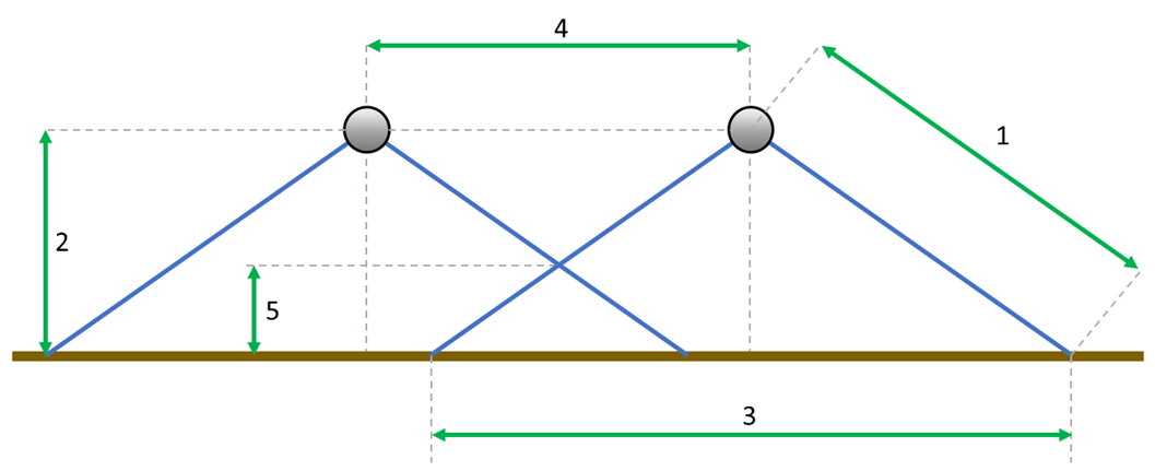
Schematic of the main parameters of two neighboring TOPODRONE scans on the side projection.
The density of the received point cloud depends on such factors as: flight speed, flight altitude, surface reflectivity. As nominal initial values it is recommended to conduct flights at a drone flight speed of 6 m/s at a working altitude of 60 m for TOPODRONE 100 LITE, HI-RES and 120 m for TOPODRONE ULTRA with 40-60% overlap. Further changes of these parameters should be made taking into account the terrain, weather conditions and maximum height of scanned objects.