
Base Station Installation and Phase Center Coordination
ДляTo обеспеченияpost-process возможностиdata постобработкиfrom данных сthe TOPODRONE DJI AIR 2S2 PPK методомusing PPK,the вPC процессеmethod, работыa дронаworking необходимоbase наличиеstation работающейis базовойrequired. станции.The Времяoperating работыtime базовойof станцииthe должноbase полностьюstation включатьshould вfully себяinclude временныеthe интервалыdrone's работыoperating дрона.time Базоваяintervals. станцияThe –base этоstation ГНССis приёмник,a выполняющийGNSS статическиеreceiver измеренияthat вperforms неподвижномstatic виде.measurements while stationary.
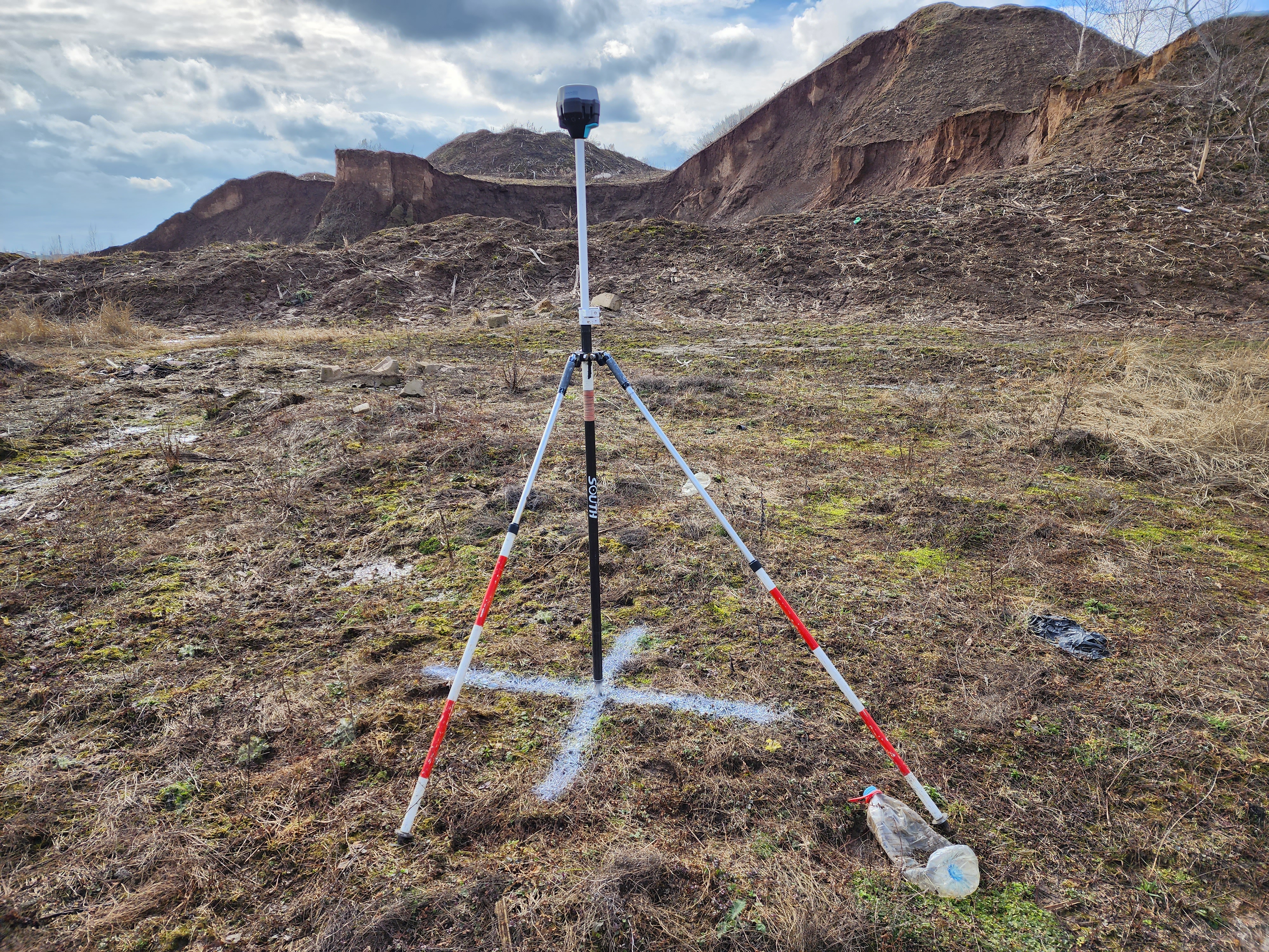
Рис.Reach 7.RS2 Установленныйreceiver приёмникoperating Reachin RS2,base работающийstation в режиме базовой станции на биподе на кресте из краски.mode.
НижеTo приводятсяperform требованияcorrect кdata Базовойpostprocessing, станцииthe дляfollowing выполненияrequirements корректнойapply постобработкиto данных:the base station:
ВремяTheработыbaseБСstationдолжноoperationвключатьtimeвshouldсебяincludeвремяtheработыdroneдронаoperation time- The maximum distance between the base station and the furthest point of the drone's route should be less than 25 km. To achieve the best accuracy and data quality, it is recommended to install the base station no further than 10 km from the flight location.
- The frequency of GNSS measurements data recording is 1 Hz.
- Base station output file format: RINEX
- Satellite groupings: GPS / GLONASS. Optional: GALILEO, BEIDOU.
- The base station should not move during operation, optimally use a tripod or a milestone with a bipod.
- The base station should be located in a place with the maximum GNSS signal reception, in an open, elevated space, away from houses, hills, power lines, roads and railway tracks.
МаксимальнаяTheдистанцияcoordinatesмеждуofБСtheиGNSSсамойphaseудаленнойcenterточкойofмаршрутаtheдронаbaseдолжнаstationбытьantennaнеshallболееbe25coordinatedкм.inДляtheдостиженияcoordinateнаибольшейsystemточностиinиwhichкачестваtheданныхprojectрекомедутесяwasустанавливать БС не далее 10 км от места проведения полёта.Частота записи данных ГНСС измерений – 1 Гц.Формат выходного файла БС:RINEXСпутниковые группировки:GPS/GLONASS. Опционально:GALILEO,BEIDOU,Базовая станция не должна двигаться в процессе работы, оптимально использовать штатив или веху с биподом.Базовая станция должна располагаться в месте с максимальным уровнем приёма ГНСС сигнала, на открытом, возвышенном пространстве, вдали от домов, холмов, ЛЭП, дорог и ж/д путей.Координаты фазового центра ГНСС антенны базовой станции должны быть закоординированы в МСК проекта, в котором выполняется работа.performed
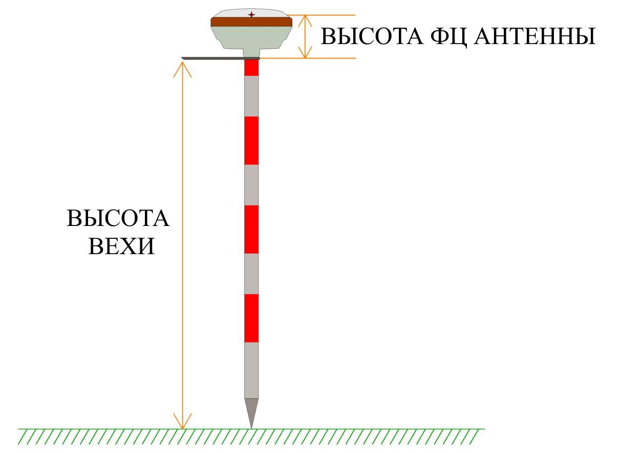
The difference in the height of the milestone and the height of the phase center
When coordinating the phase center of the GNSS antenna of the base station, the height of the milestone and the height of the Phase Center itself should be taken into account,, which is also offset from the lower plane of the GNSS receiver body, should be taken into account.
It has been experimentally established that the use of additional GALILEO and BEIDOU satellite systems reduces accuracy when used in post-processing by the RRK method for moving objects. It is recommended to use GPS/GLONASS.
Рис.In 8.case the accuracy of solutions for coordinates of photo centers is not high enough, you should try to leave only GPS.
if the Разницаaccuracy вof высотеthe вехиsolutions иfor высотеthe фазовогоcoordinates центраof the photographing centers is not high enough, only GPS should be left.
 При
Привыполненииyou координированияplace ФЦan ГНССidentification антенныmark БСunder следуетthe учитыватьbase высотуstation, вехиthen иit высотуcan самогоbe Фазовогоused Центра,as которыйa такground жеcontrol имеетpoint, офсетwith отa нижнейheight плоскостиless корпусаthan ГНССthe приёмникаhigh-precision (см.coordinates рисof 7).the FS antenna of the BS at the height of the milestone and the height of the FC.
 Опытным путём установлено, что использование дополнительных спутниковых систем
 GALILEO, BEIDOU снижает точность при использовании в постобработке методом РРК для подвижных объектов. Рекомендуется использовать GPS / GLONASS.
 В случае, если точность решений для координат центров фотографирования недостаточно высокая, следует попробовать оставить только
 GPS.
 При наличии возможности, установив опознавательный знак под БС, можно использовать его как наземную контрольную точку, с высотой меньше высокоточных координат ФЦ антенны БС на высоту вехи и высоту ФЦ (см. рис. 8)