
Aerial photography
ВыберитеSelect вкладкуthe "Аэрофотосъемка"Aerial дляPhotography настройкиtab параметровto обработкиcustomize модулейthe processing parameters of the PPK Post Processing иand RTK Post Processing.Processing modules.
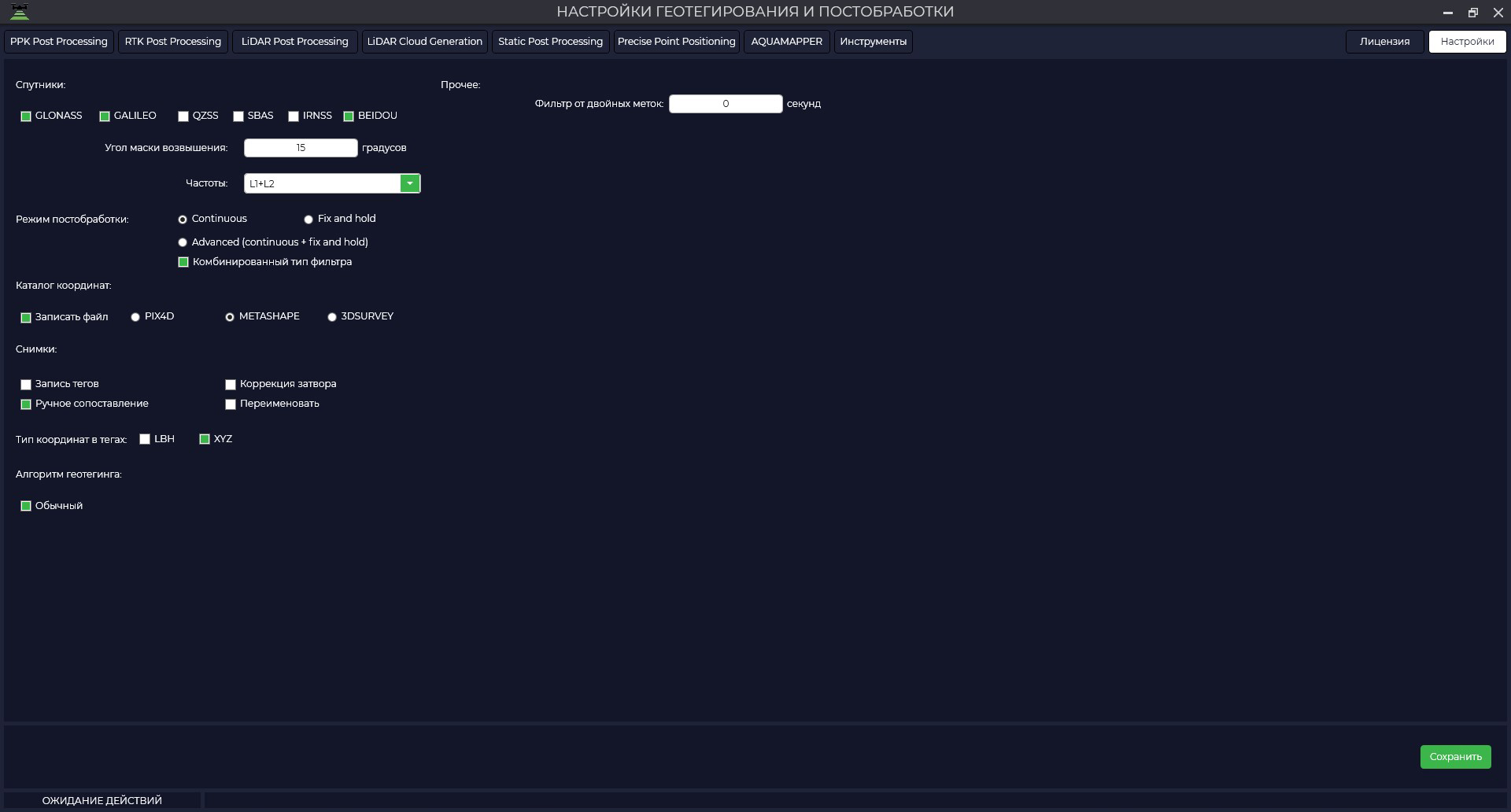 In the "Satellites" window you can enable or disable certain satellite constellations from processing, specify the required elevation mask and select the frequencies for which you want to perform processing.
В окне «Спутники» можно включить или отключить из обработки определенные спутниковые группировки, указать необходимую маску возвышения и выбрать частоты, по которым необходимо выполнить обработку.

ВIn окнеthe РежимPostprocessing постобработкиMode можноwindow, выбратьyou одинcan изselect параметров:from Continuous, Fix and holdhold, илиor Advanced.

ВIn режиме «"Fix and Hold»Hold" программаmode, стремитсяthe получитьprogram фиксированноеstrives решениеto позиционирования,obtain котороеa обеспечиваетfixed наивысшуюpositioning точностьsolution иthat надежность.provides Онthe используетhighest информациюaccuracy отand базовойreliability. станцииIt иuses ровераinformation дляfrom вычисленияthe относительнойbase позицииstation иand затемrover усиливаетto этоcalculate решение,the чтобыrelative достичьposition фиксации.and Когдаthen достигаетсяamplifies фиксация,this программаsolution удерживаетto этоachieve решениеa какfix. можноWhen дольше,a дажеfix еслиis качествоachieved, сигналаthe временноprogram падаетholds илиthis некоторыеsolution спутникиfor теряются.as long as possible, even if the signal quality temporarily drops or some satellites are lost.Цель
The «purpose of the "Fix and Hold»Hold" –mode обеспечитьis стабильноеto иprovide надежноеa фиксированноеstable решение,and чтоreliable особенноfixed полезноsolution, вwhich геодезическихis приложениях,particularly гдеuseful требуетсяin высокаяsurveying точностьapplications иwhere долговременнаяhigh стабильность.accuracy Этотand режимlong-term можетstability бытьare предпочтительным,required. когдаThis важноmode избегатьmay переключенийbe междуpreferred решениямиwhen иit обеспечитьis непрерывностьimportant фиксацииto дажеavoid вswitching условияхbetween временныхsolutions измененийand to ensure continuity of the fix even in the face of temporal changes (например,e.g. отраженияsignal сигналовreflections илиor прохождениеpassing черезthrough преграды)obstacles).ВIn режиме"Continuous" «Continuous»mode алгоритмthe обрабатываетalgorithm данныеprocesses непрерывноdata иcontinuously обновляетand результатыupdates позиционированияpositioning поresults мереas полученияnew новыхdata данных.is Вreceived. отличиеIn отcontrast режимаto «the "Fix and Hold»,Hold" здесьmode, программаhere неthe фиксируетprogram решение,does аnot непрерывноfix вычисляетthe позициюsolution, ровераbut наcontinuously основеcalculates текущихthe данных.rover Приposition полученииbased новыхon наблюдений,the программаcurrent обновляетdata. позицию,When учитываяnew этиobservations данныеare иreceived, предыдущиеthe результаты.program updates the position taking into account these data and previous results.РежимContinuous «Continuous»mode обеспечиваетprovides болееmore актуальныеrelevant результатыpositioning позиционирования,results посколькуbecause онit непрерывноcontinuously обновляетupdates позициюthe наposition основеbased последнихon данных.the Онlatest можетdata. бытьIt полезенcan вbe приложениях,useful гдеin актуальностьapplications иwhere динамическиеrelevance измененияand позицииdynamic болееposition важны.changes are more important.Выбор
The режимамиchoice between "Fix and Hold"Hold" иand "Continuous"Continuous" зависитmodes отdepends конкретныхon требованийthe иspecific условийrequirements приложения.and Еслиconditions важнаof стабильностьthe иapplication. надежностьIf фиксацииstability решения,and особенноreliability вof статическихsolution условиях,fixation режимis important, especially under static conditions, the "Fix and Hold"Hold" можетmode бытьmay предпочтительным.be Еслиpreferred. жеIf актуальностьrelevance иand динамикаdynamic позиционированияpositioning играютare болееmore важную роль, режимimportant, "ContinuousContinuous" mode provides a more continuous position update based on the latest data.
The "Advanced" обеспечиваетmode болееis непрерывноеa обновлениеcombination позицииof наthe основеprevious последнихmodes данных.Режимwith «Advanced»all являетсяtheir комбинациейpluses, предыдущихbut режимовdata соprocessing всемиtakes ихa плюсами,little но обработка данных занимает немного больше времени.longer.
ВIn окнеthe «Каталог"Coordinate координат»Catalog" необходимоwindow, поставитьyou галочкуshould «Записатьcheck файл»the для"Write сохраненияFile" каталогаbox центровto фотографированияsave иthe выбратьcatalog форматof файлаphoto дляcenters используемойand Вамиselect программыthe file format for the program you are using.

In the "Photos" window you can save the coordinates of the photo centers in the EXIF file of the photo, assign a unique name to the photos depending on the time of creation, it is recommended to check the "Manual matching" checkbox for correct matching of photos and marks, the "Shutter correction" checkbox is responsible for shifting the mark by half the shutter time.

In case you checked "Write tags" in the previous window, you should select the format of coordinates saving (LBH - geographic coordinates, XYZ - rectangular coordinates).

ВThe окне"Geotagging «Снимки»Algorithm" можноtab сохранитьcontains координатыsettings центровto фотографированияhelp вthe EXIFprogram файлmatch фотографии,photos присвоитьand фотографиямtags уникальноеin имяthe вevent зависимостиof отa времениquantity создания,mismatch.
Normal рекомендуется- поставитьthe галочкуalignment «Ручноеis сопоставление»,done дляin правильногоthe совмещениеorder фотографийof иthe меток,photos галочкаtaken.
Increase «Коррекцияtime затвора»weighting отвечает- заmatching смещениеis меткиbased наon половинуthe времениtime выдержки.

Вand случае,tags еслиwere вcreated.
Increase предыдущемcoordinates окнеweight поставили- галочкуMatching «Записьis тегов»,performed тоby необходимоnavigation выбратьcoordinates форматof сохраненияphotos координатcontained (LBHin –tags географическиеand координаты,high-precision XYZcoordinates –of прямоугольныеtags координаты)

Наresult вкладкеof «Алгоритмpost-processing геотегинга» находятся настройки, позволяющие помочь программе совместить фотографии и метки в случае несоответствия количества. Обычный – совмещение происходит по порядку сделанных фотографий.Увеличивать вес времени – совмещение происходит по времени создания фотографий и меток.Увеличивать вес координат – Совмещение происходит по навигационным координатам содержащихся в тегах фотографий и высокоточным координатам меток в результате постобработки в программеin TOPODRONE Post Processing.Processing program.

ПриIn маршрутах,case вof которыхroutes одниwhere фотографииsome накладываютсяphotos наare другиеoverlapped алгоритмwith совмещенияother поphotos, координатамthe можетcoordinate работатьmatching неalgorithm корректно.may Пример:not маршрутwork наcorrectly. одномExample: аккумулятореroute приon съемкеone небольшогоbattery объектаwhen дляshooting 3Дa реконструкции.small Вobject случаеfor съемки,3D когдаreconstruction. камераIn направленаthe вcase надир,of аshooting затемwhen сразуthe происходитcamera съемка,is когдаpointing летательныйat аппаратnadir производитand съемкуthen перспективы.immediately shooting when the aircraft is shooting perspective.
ФильтрThe отdouble-tag двойныхfilter метокallows позволяетyou наto этапеremove постобработкиunnecessary удалитьtags лишниеat метки.the Значениеpost-processing поstage. умолчаниюDefault value 0.2 секунды.seconds.
