Grid equalization
ДляToзапускаstartданногоthisмодуляmodule,прейдитеgoнаtoвкладкуthe Static Post ProcessingиtabнажатьandнаclickкнопкуonУравниваниеtheсетей.Network Equalization button.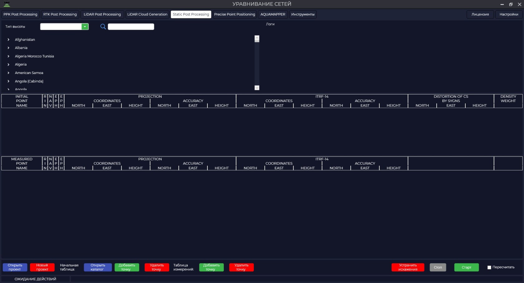

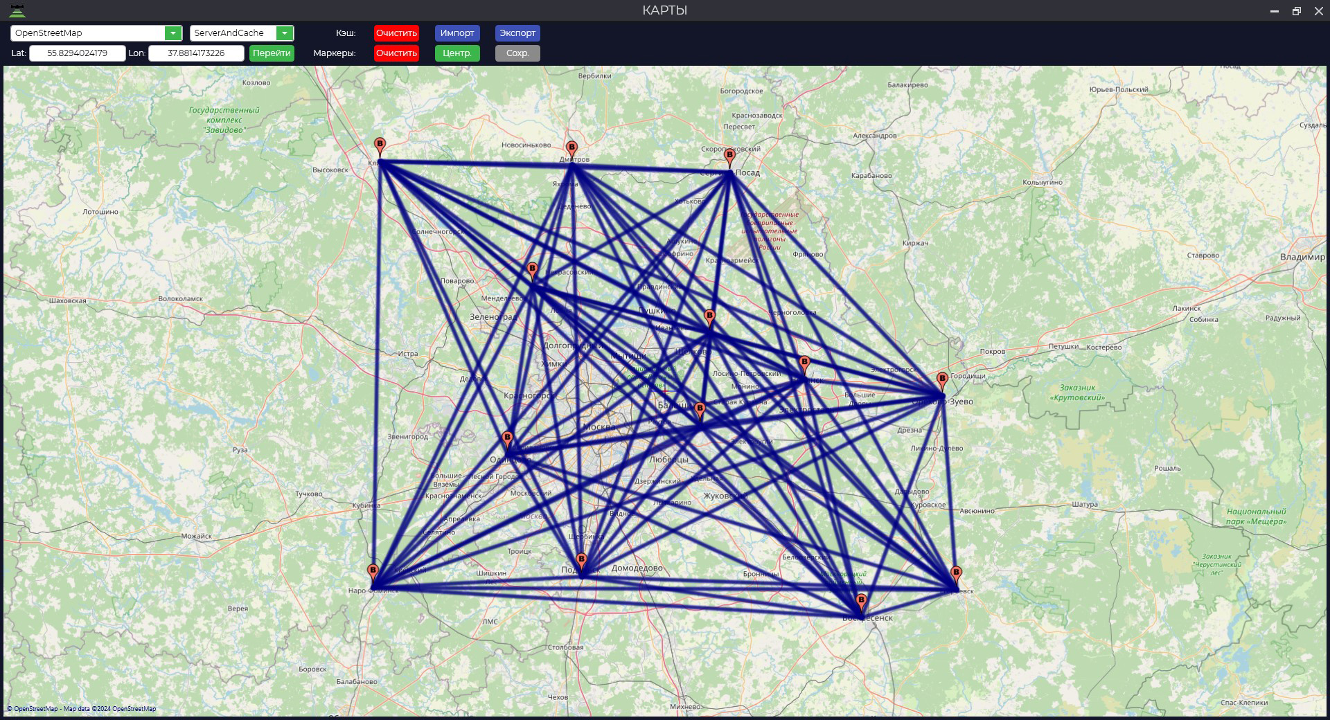
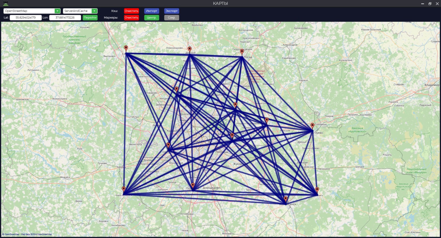
ДляToотображенияdisplayпунктов,theнаpointsкоторыхwhereпроизводилисьobservationsнаблюденияwereнеобходимо,made,чтобыtheокноmapкартыwindowнаmustмоментbeзагрузкиopenфайловatбылоtheоткрыто.time of file upload.

НаTheнижнейbottomпанелиpanelестьhasрядaинструментов:numberоткрытьofилиtools:создатьopenновыйorпроект,createоткрытьaкаталогnewисходныхproject,пунктов,openдобавитьtheилиsourceудалитьpointфайлыcatalog,исходныхaddпунктов,orдобавитьdeleteилиsourceудалитьpointфайлыfiles,измеряемыхaddпунктов,orустранитьdeleteискаженияmeasuredпроекции,pointостановитьfiles,обработкуremoveиprojectionрассчитать.distortions, stop processing, and calculate.


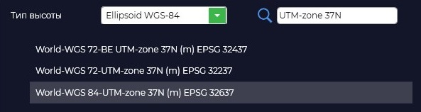
ПервымTheделомfirstнеобходимоthingвыбратьtoнеобходимуюdoпроекциюisиtoтипselectиспользуемойtheвысоты.required projection and the type of elevation to be used.

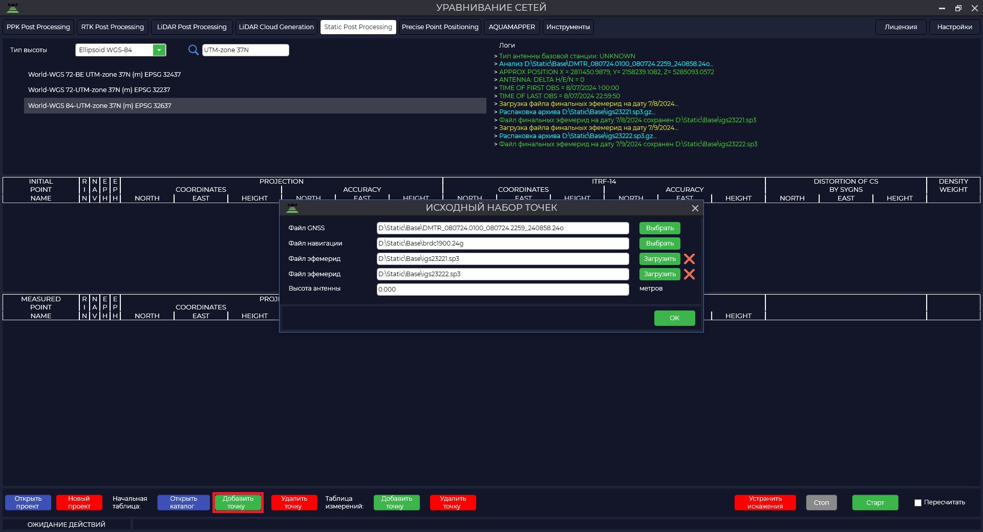
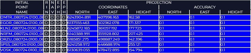
ПриWhenнажатииweнаclickкнопкуon«Добавитьtheточку»"AddнапротивPoint"пунктаbutton«Начальнаяnextтаблица»toнамtheнеобходимо"StartзагрузитьTable"данныеitem,поweисходнымneedпунктам.to load the data for the starting points.


ФайлGNSS file - a GNSS–receiverфайлmeasurementизмеренийfileс ГНСС приемника в форматахin *.obs, *.rnxилиor *.*o.o formats.ФайлNavigationнавигацииfile–-навигационныйnavigationфайлfileизмеренийofвmeasurementsформатеin *.nav, *.rnx, *.n, *.p, *.g, *.h, *.q, *.cиand *.l.l format.ФайлEphemerisэфемеридfile–-файлfileфинальныхofэфемеридfinalвephemerisформатеin *.sp3, *.eph,ephтакжеformat,можноyouподгрузитьcanфайлalsoточныхuploadбортовыхaчасовfile of accurate flight clock *.clk.ПриWhenнажатииyouнаclickкнопкуonDownload,theприDownloadналичииbutton,данныхifнаtheсервереdataНАСА,areпрограммаavailableавтоматическиonскачаетtheэтиNASAданные.server, the program will automatically download these data.
ПриWhenобработкеprocessingУравниваниеtheсетейGridпрограммаEquation,используетtheметодprogramполученияusesвысокоточныхtheкоординатmethod(of obtaining Precise Point Positioning–(PPP)местностиcoordinatesсofпомощьюtheглобальныйterrainнавигационныхusingспутниковыхglobalсистемnavigationпосредствомsatelliteполученияsystemsпоправокbyкobtainingэфемеридамcorrectionsорбитtoиtheбортовымorbitalчасамephemerisвсехandвидимыхon-boardкосмическихclocksаппаратов.ofДляallнаилучшегоvisibleрасчетаspacecraft.рекомендуетсяForдобавитьtheсуточныеbestизмеренияcalculationсitближайшейisреференснойrecommendedбазовойtoстанцииaddилиdaily measurements from the nearest reference base station or IGS.ВысотаAntennaантенныheight–isвысотаtheотheightцентраfromпунктаtheдоcenterфазовогоofцентраtheГНССpointприемника.to the phase center of the GNSS receiver.
ТипTypeТочностьAccuracyорбитofиorbitsчасовand clocksДоступностьAccessibilityПримечаниеNoteТекущие (Broadcast)Broadcast~100 см
~5нсnsСКОRMS
~2.5нсns σВInреальномrealвремениtimeОбобщенные в ЦУП бортовые эфемериды ГЛОНАССGLONASS (.YYg)иand GPS (.YYn)заon-boardсуткиephemerisвforформатеa day in RINEX format summarized in the TsUPУточненные (UltraRapid)UltraRapid~3 см
~150псnsСКОRMS
~50псns σЧерезIn 3-9часовhoursУточненныеRefinedэфемеридыephemerisиandпоправкиcorrectionsбортовыхofчасовairborne clocksТочные (Rapid)Rapid~2.5 см
~75псnsСКОRMS
~25псns σЧерезAfter 17-41часовhoursЭфемеридыEphemerisиandпоправкиcorrectionsбортовыхofчасов,onboardполученныеclocksнаobtainedинтервалеonпоследнихtheсутокinterval of last daysФинальные (Final)Final~2.5 см
~75псnsСКОRMS
~20псns σЧерезAfter 12-18днейdaysФинальныеFinalэфемеридыephemerisиandпоправкиflightбортовыхclockчасовcorrectionsПриWhenдобавленииaddingисходныхinitialданныхdataвtoпрограммуtheвыйдетprogram,окноaоwindowвнесенииwillкоординатappearпунктаonизenteringзагружаемогоcoordinatesфайла,ofнажимаемtheкнопкуpoint from the loaded file, click the "Да".Yes" button.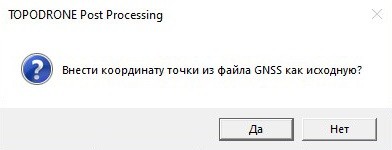

ЗатемThen,приifнеобходимостиnecessary,загружаемloadкаталогtheкоординатcoordinateисходныхcatalogпунктовofилиtheвводимsourceкоординатыpointsиorточностьenterихtheопределенияcoordinatesвручную.and their accuracy manually.
•

ЕслиIfвыyouнеdoзнаетеnotсknowкакойwithточностьюwhatониaccuracyбылиtheyопределены,haveтоbeenВамdetermined,необходимоyouуказатьshouldследующиеprovideрекомендуемыеtheточности:following recommended accuracies:ФАГСFAGS 20ммmmсевер/восток,north/east, 30ммmmвысота;high;
•ВГСHCV3030mmммnorth/east,север/восток,40mm40 мм высота;high;
•АГСAGSиandСГСGHS4040mmммnorth/east,север/восток,50mm50 мм высота;high;
•ГГСGGS6060mmммnorth/east,север/восток,110mm110 мм высота.high.
ДляToзагрузкиloadданныхtheпоdataизмеряемымforпунктамmeasuredнеобходимоpoints,воспользоватьсяyou«Добавитьmustточку»useнапротив"Addпунктаpoint"«Таблицаagainstизмерений»theиitemпо"Measurementаналогииtable"сandисходнымиperformпунктамиtheвыполнитьloadingзагрузку.by analogy with the original points.


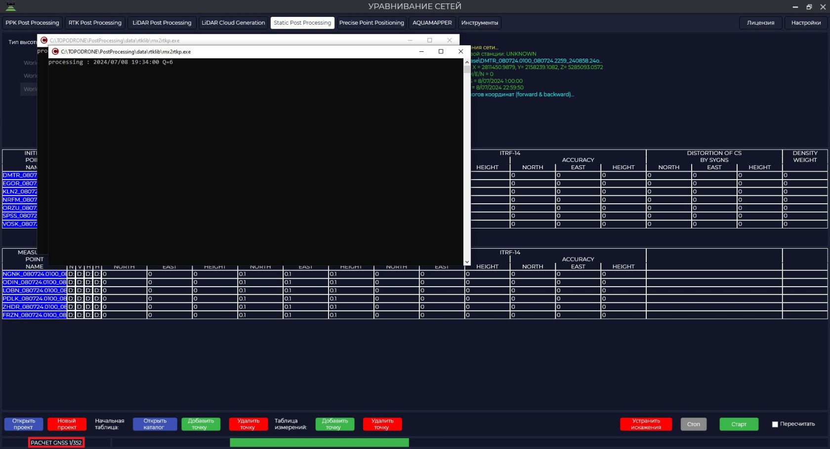
ПослеOnceзагрузкиallвсехitemsпунктовhaveнажмитеbeenнаloaded,кнопкуclick«Старт»onпрограммаtheначнет"Start"расчет.buttonСлеваandснизуtheбудетprogramотображатьсяwillколичествоbeginоперацийtheиcalculation.сколькоTheвсегоnumberнеобходимоofвыполнитьoperationsрасчетов.and the total number of calculations to be performed will be displayed on the bottom left.

РасчетTheсетиcalculationидетofпоtheследующемуnetworkалгоритму:follows the following algorithm:
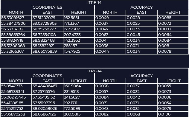
1)РасчетCalculationкоординатofвсехcoordinatesпунктовofвallсистемеpointsкоординатin ITRF2014методомcoordinate system by Precise Point Positioning–-PPP.PPPПослеmethod.этогоAfterэтапаthisвstepокнеin the ITRF-14выwindowувидитеyouрассчитанныеwillкоординатыseeиtheточность,calculatedсcoordinatesкоторойandониtheirполучились.accuracy.
2)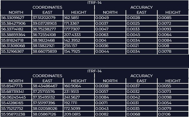

НаInследующемtheэтапеnextпрограммаstep,выполняетtheвычисленияprogramкоординат пунктов методомperforms Precise Point Positioningиandстатическоеstaticизмерениеmeasurementвсехofвозможныхallвекторов,possibleвыполняетvectors,вычислениеperformsкоординатpointпунктовcoordinatesвзвешиваниемcalculationпоbyточностям.precision weighting.
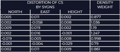
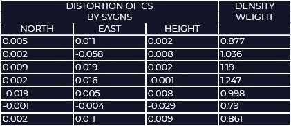
3)ЗатемThen,используяusingсистемуtheкоординатcoordinateиsystemкоординатыandисходных,coordinatesсofучетомtheвесовыхinitialточностейpoints,пунктов,takingпрограммаintoвычисляетaccountобщееtheсмещениеweightingотaccuraciesпараметровofвыбраннойtheпроекцииpoints,иtheсоздаетprogramсеткуcalculatesостаточныхtheпоправокtotalискажений.displacement from the parameters of the selected projection and creates a grid of residual distortion corrections.ВInокнеthe DISTORTION OF CS BY SYGNSможноwindowувидетьyouостаточныеcanискаженияseeсистемыtheкоординатresidualотносительноdistortionsисходныхofпунктов.theВcoordinateокнеsystem relative to the original points. In the DENSITY WEIGHTПлотностьwindowточек,Densityонаofнужнаpoints,дляitувеличения/уменьшенияisвесаneededискажений,toодинокаяincrease/decreaseточкаtheимеетweightбольшийofвесdistortions,чемaточка,singleкотораяpointнаходитсяhasрядомaсhigherдругими.weight than a point that is next to others.

ПоитогуAs
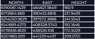
вычисленийaвыresultполучитеofкаталогcalculationsкоординатyouпунктовwillвgetтойaсистемеcatalogкоординат,ofкотораяcoordinatesбылаofзадана,pointsточностьinопределенияtheэтихcoordinateкоординатsystemиthatсеткуwasискаженийspecified,дляaccuracyиспользованияofвdeterminationпрограммеof these coordinates and distortion grid for use in the TOPODRONE PostProcessing.ProcessingФайлprogram.калибровкиTheможноcalibrationоткрытьfileчерезcanмодульbe«Инструменты»openedвкладкаthrough«Калибровка».theКроме"Tools"того,module,отчет"Calibration"оtab.результатахInобработкиaddition,сохранитьсяaвreportпапкеofсtheдокументами.processing results will be saved in the document folder.

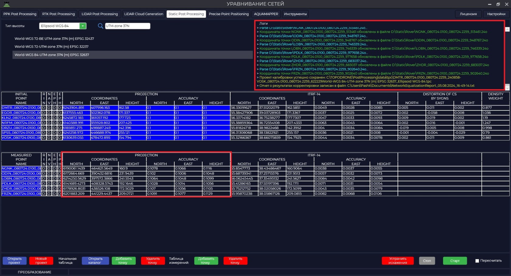
ПриWhenнажатииyouкнопкиclick the "УстранитьCorrectискажения"Distortion"программаbutton,распределяетtheошибкиprogramпоdistributesисходнымtheпунктамerrorsиtoзановоtheвыполняетsourceобработку.items and re-runs the processing.


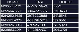
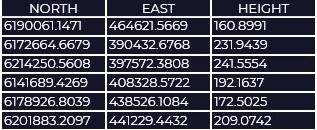
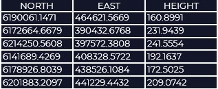
ВTheтаблицеtableнижеbelowпредставленыsummarizesрезультатыtheобработкиresults of processing
Caption До устранения искажений После устранения искажений