Flight path planning with TOPODRONE laser scanner for ALS
|
In case of insignificant height differences in the place of VLS (up to 10 meters) it is allowed to fly the drone with TOPODRONE laser scanner at a fixed altitude. The height of the drone's flight is set relative to the height of the takeoff point. The free DJI Pilot app is suitable for fixed-altitude flights for area and line missions, (installed on the Android operating system for DJI M200 drones) and DJI Pilot 2 for DJI M300 / M350 drones.
In the DJI Pilot software, to ensure proper side overlaps, it is necessary to create a camera profile with the following parameters shown in Pictire.. Then - specify the route area with % overlap according to Table 1 ДанныеThese параметрыparameters взятыare наtaken основеon параметровthe фотокамерыbasis of parameters of Sony RX1RM2 сcamera измененнымwith значениемchanged фокусногоvalue расстоянияof сfocal length from 35 ммmm наto 13.5 мм.mm.
ПриIf перепадахthe высотaltitude наdifference локацииin проведенияthe ВЛСALS болееlocation is more than 10 метров,meters, требуетсяit выполнениеis полетаrequired дронаto сfly лазернымthe сканеромdrone with TOPODRONE вlaser режимеscanner «огибанияin рельефа»the или“terrain сenvelope” фиксированнойmode высотойor относительноwith поверхностиfixed (AGL).altitude Дляrelative планированияto миссиthe вsurface. To plan a mission in AGL необходимоyou специальноеneed ПО,special напримерsoftware such as UgCS Pro / Expert, Map Pilot 1 / 2. Для полета по рельефу в базовом приложении DJI Pilot 2 необходимо наличие DTM (Digital Terrain Model). is required for terrain flight in the DJI Pilot 2 base application.
ПланированиеIt полетныхis маршрутовrecommended рекомендуетсяto сplan соблюдениемflight значенийpaths расстоянийwith междуscan сканамиspacing вvalues соответствииaccording сto ТаблицейTable 1. дляto полученияobtain рекомендуемыхrecommended значенийvalues боковыхof перекрытийlateral междуoverlaps сканами.between scans.
В ПОIn UgCS Pro дляsoftware площадныхfor миссийarea можноmissions, использоватьyou инструментcan «сканированиеuse области»the с“area указаниемscan” рабочейtool высотыwith сканированияthe иworking расстоянийscan междуheight сканамиand вscan соответствииspacing сvalues according to ТаблицейTable 1.
|
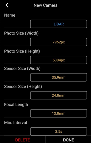
Рис.Parameters 16.for ПараметрыTOPODRONE дляlaser лазерныхscanners сканеров TOPOPDTONE приложенияof DJI Pilot application
|
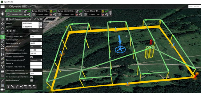
Рис.Area 17.Scan Инструментtool «Сканированиеfor области»performing дляALS выполнения ВЛС в режимеin AGL наmode TOPODRONE100on вTOPODRONE приложении100 in the UgCS Pro application.
