
Flight path planning with TOPODRONE laser scanner for ALS
|
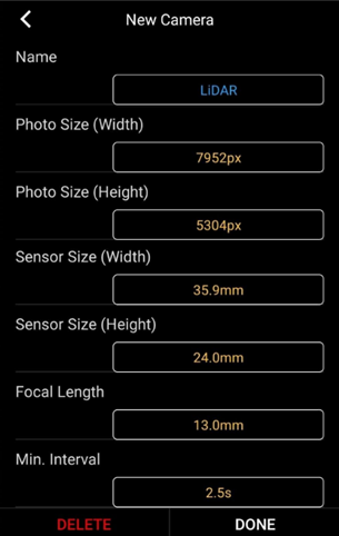
In case of insignificant height differences in the place of ALS (up to 10 meters) it is allowed to fly the drone with TOPODRONE laser scanner at a fixed altitude. The height of the drone's flight is set relative to the height of the takeoff point. The free DJI Pilot app is suitable for fixed-altitude flights for area and line missions, (installed on the Android operating system for DJI M200 drones) and DJI Pilot 2 for DJI M300 / M350 drones. In the DJI Pilot software, to ensure proper side overlaps, it is necessary to create a camera profile with the following parameters shown in Pictire.. Then - specify the route area with % overlap according to Table 1 These parameters are taken on the basis of parameters of Sony RX1RM2 camera with changed value of focal length from 35 mm to 13.5 mm. If the altitude difference in the ALS location is more than 10 meters, it is required to fly the drone with TOPODRONE laser scanner in the “terrain envelope” mode or with fixed altitude relative to the surface. To plan a mission in AGL you need special software such as UgCS Pro / Expert, Map Pilot 1 / 2. DTM (Digital Terrain Model) is required for terrain flight in the DJI Pilot 2 base application. It is recommended to plan flight paths with scan spacing values according to Table 1. to obtain recommended values of lateral overlaps between scans. |
Parameters for TOPODRONE laser scanners of DJI Pilot application |
No Comments