
IMU calibration pattern
Before starting each route for ALS or MLS on the TOPODRONE LiDAR, a calibration pattern must be performed after the initialization procedure. This pattern is performed to calibrate the IMU module inside the TOPODRONE LiDAR. Without performing this calibration pattern before starting the route, the data quality may not be satisfactory. During the calibration process on the aircraft, it is necessary to move in a plane at operating altitude in a circular pattern once clockwise and once counterclockwise, the sequence does not matter. An important point is the need to change the spatial position of the TOPODRONE LiDAR, in this regard, the option with rotation around its axis, similar to the compass calibration on DJI drones, is not suitable.
Performing calibration of TOPODRONE ALS laser scanner in automatic mode. There are two ways to perform the figure-eight calibration pattern on DJI drones: automatic and manual. The possibility of automatic execution depends on the flight planning software used. UgCS Pro / Expert software allows you to perform the calibration procedure in automatic mode.
To perform an automatic figure-of-eight flight in UgCS software, follow the steps below:
- Create a new route by selecting the desired drone profile and setting the desired parameters for return altitude, actions in case of loss of remote control signal, etc.
- Using the Waypoint tool, set the takeoff point, which will be the first waypoint of the route. Set the "height above ground" parameter according to the working altitude.
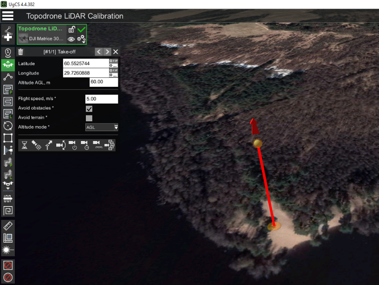
Setting the waypoint before starting the calibration pattern "figure eight" in UgCS Pro / Expert software.
- Using the Circle Flight tool with a double left mouse click, create a circle flight so that it touches the first "Takeoff" waypoint. It is recommended to use/change the following parameters:
- Altitude: 60-120 m according to the working altitude for your sensor (see point 2).
- Range: 10-60 meters
- Flight speed: 6-10 meters per second
- Turn Type: Adaptive Bank Turn (this parameter smooths out corners)
- Clockwise traversal: yes (no for the second lap)
- Number of approximating points: 7
- Follow the terrain: no
- Altitude mode: AGL (altitude will be calculated relative to the terrain)
- POI – delete (by default, the POI orients the drone's front to the center of the circle)
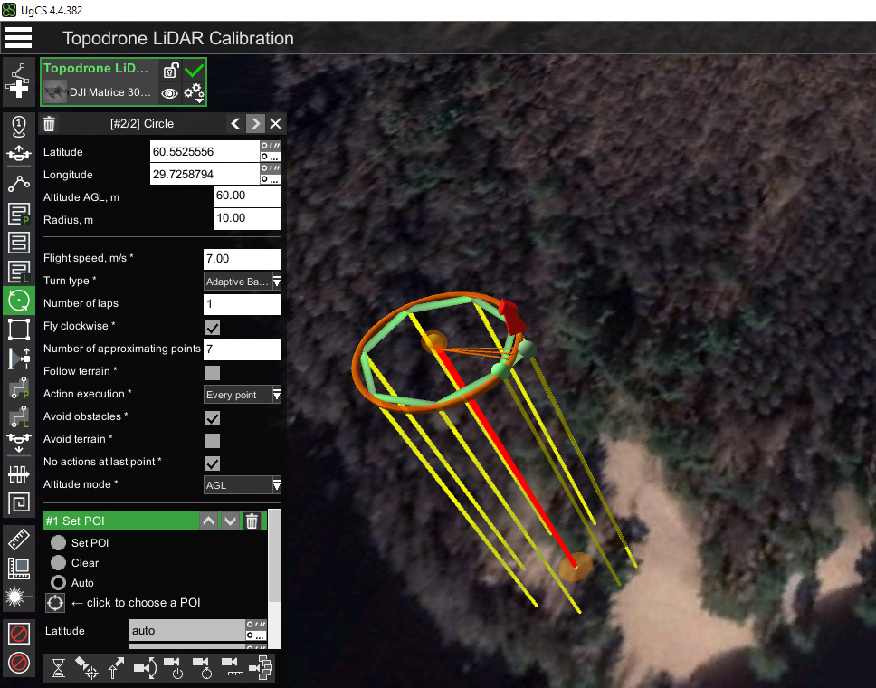
Setting the first circle of the calibration pattern "figure eight" in UgCS Pro / Expert software. Pay attention to the necessity of deleting the POI action
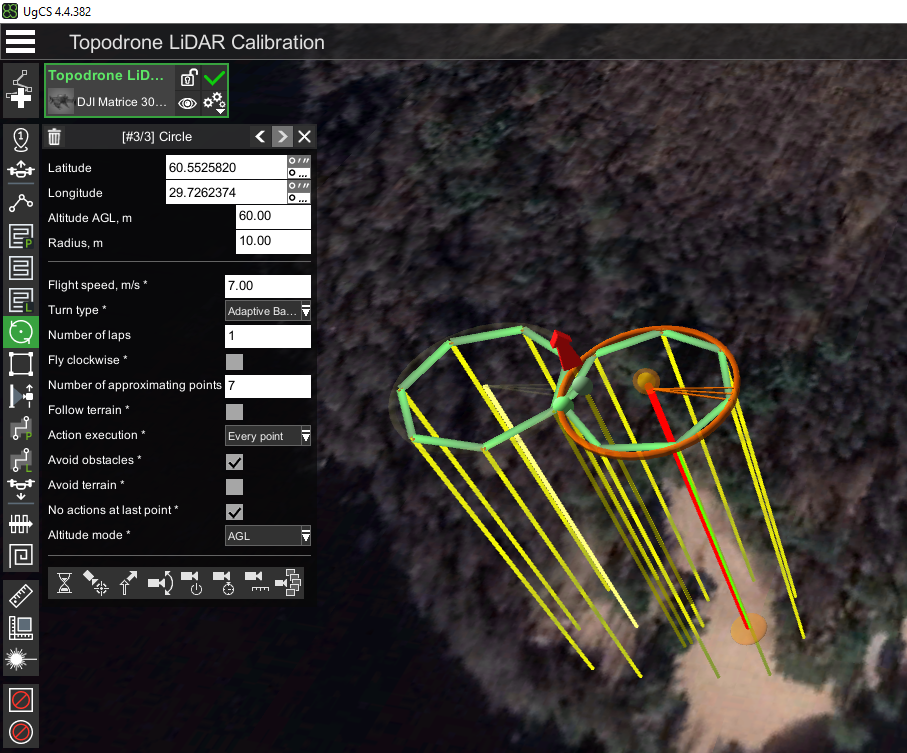
- Using the Circle Flight tool with a double left mouse click, create a second circle flight so that it touches the first waypoint and the first circle. It is recommended to use the same parameters as in step. 3, except for the "Clockwise traversal" parameter, which should be different for the two circles. Clockwise traversal: no (yes for the second circle)

Setting the second circle of the calibration pattern "figure eight" in UgCS Pro / Expert software.
Note the need to fly in circles in different directions.


Calibration of the TOPODRONE ALS laser scanner in manual mode.
If it is impossible to perform the calibration pattern in automatic mode (no UgCS Pro / Expert software), it is necessary to perform this pattern in manual mode before starting the flight along the main route. To do this, perform the following actions:
- Prepare the DJI quadcopter and TOPODRONE LiDAR for use in open terrain, according to the instructions, when there is sufficient GNSS signal strength.
- Turn on the drone, wait for the initialization procedure of the drone and TOPODRONE LiDAR
- Calibrate the DJI quadcopter compass before launching the drone, according to the drone's instructions.
- Performing compass calibration is strictly necessary each time before the first flight on a new terrain.
- Manually in P mode take off to operating altitude.
- When the drone reaches the working altitude, switch to "T" mode - Tripod (if available).
- Perform pattern using the control sticks. To fly in the first circle (clockwise), hold the left stick to the right and the right stick forward. This combination will allow the DJI quadcopter to circle while maintaining altitude. After the drone completes the first circle, without changing the right stick position (forward), change the left stick position to counterclockwise (left).
- In the case of "T" - Tripod mode, you can maneuver the sticks by pushing them to their extremes. Speed limitation and smoothness will be achieved due to the flight characteristics of the "T" Tripod mode. If the Tripod mode is not available in the quadcopter as one of the flight modes, we recommend that you maneuver the sticks as smoothly as possible without sudden movements.
- After completing the second lap pass, the calibration pattern is completed. After completing the calibration procedure of the TOPODRONE LiDAR in manual mode, send the flight task to the quadcopter and start the main part of the flight.
- While performing a figure-eight flight, you can control the turning radius of the drone using the Map view in the app on your mobile device, as well as visually by looking at the drone in flight in the sky.
Performance of the calibration pattern for MLS using TOPODRONE BackPack.
- Prepare TOPODRONE BackPack and TOPODRONE LiDAR for operation in the open terrain, according to the instructions, if there is sufficient GNSS signal strength.
- Make sure there are no objects of any kind within at least 100 meters: buildings, hills, fences, wires, etc. Power up the TOPODRONE LiDAR scanner with the included external battery and power cable.
- Wait for the laser scanner initialization procedure.
- Place the backpack over the operator's shoulders.
- Walk at a constant speed of 5-9 km/h in two circles with a radius of 10-15 meters clockwise and counterclockwise. Each circle must be closed before the start of the next stage.
- After completing the second lap pass, the calibration pattern is complete. You can proceed to the main task.
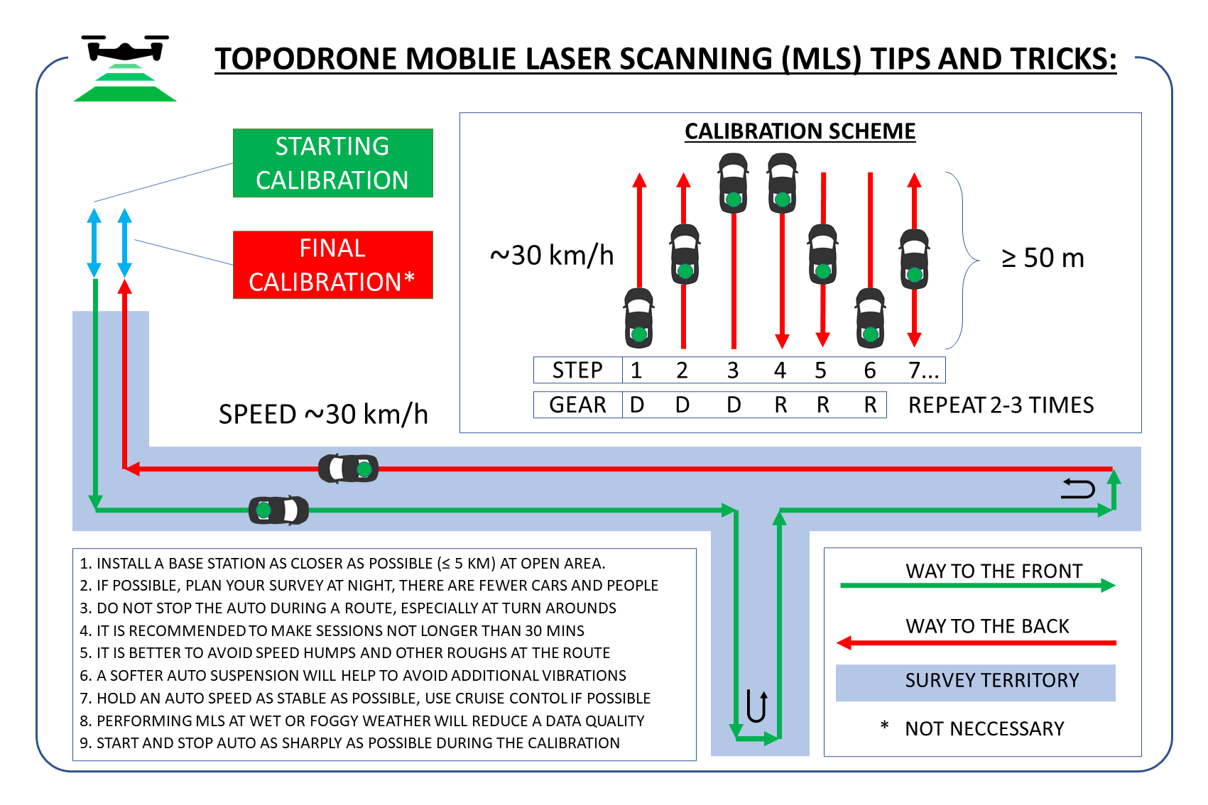
Performing the calibration pattern for the MLS when using a vehicle mount.
- Prepare the TOPODRONE car mount and laser scanner for operation in the open area according to the instructions, if there is a sufficient GNSS signal level.
- Make sure there are any objects within at least 100 meters: buildings, hills, fences, wires, etc.
- Place the car mount together with the laser scanner on the roof of the car in such a way that the cable coming out of the sensor and going into the TOPODRONE housing should face backwards in the direction of travel.
- Power up theTOPODRONE LiDAR scanner with the included external battery and power cord.
- Wait for the laser scanner initialization procedure.
- Perform a drive at a constant speed of 20-30 km/h forward for a distance of 50-100 meters with a return to the starting point in reverse at the same speed. Repeat this step 2-3 times.
- Once the passes are completed, the calibration pattern is done. You can proceed to the main task.
No Comments