
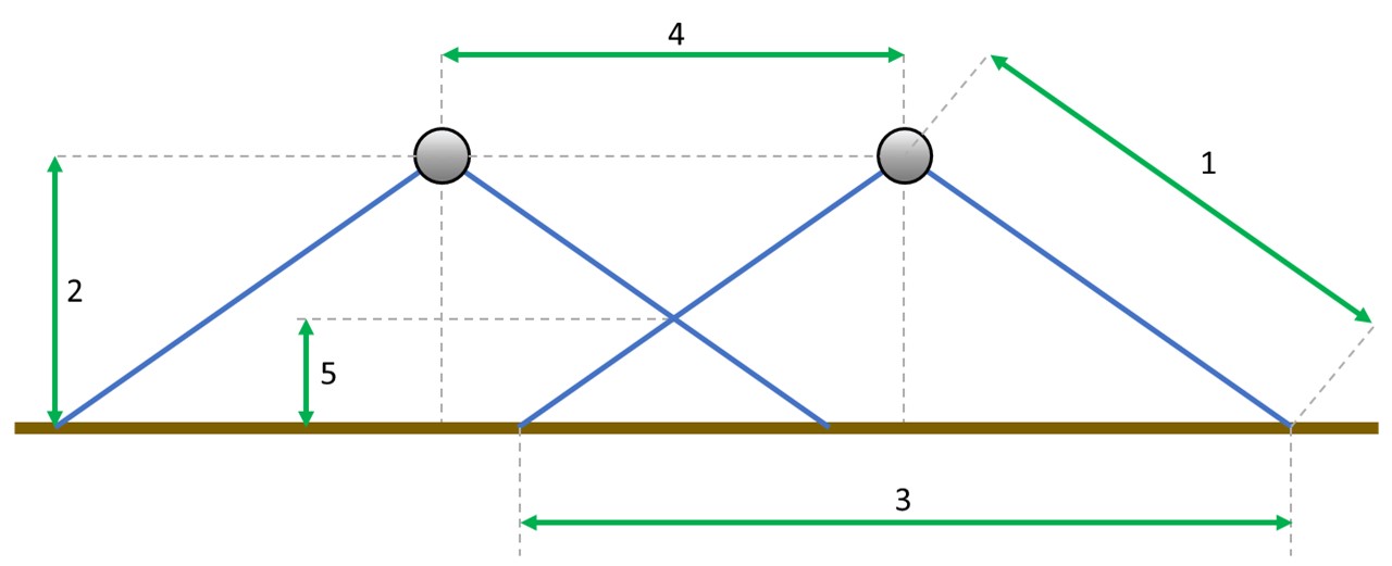
Overlaps between scans and the height of the scanned objects
During the flight, TOPODRONE LiDAR scans an area of the surface of a certain width, which is called a "scan". The width of the scan is determined by the technical characteristics of the sensor, the operating altitude of the flight, as well as the difference in terrain.
For correct postprocessing of the data obtained from TOPODRONE LiDAR, it is necessary that neighboring scans have a common overlap. It is recommended to provide at least 30% lateral overlap to adjacent scans. Insufficient overlap between scans, especially in combination with significant relief differences, can lead to the formation of an area without data, which significantly reduces the quality of output materials.
On the other hand, a higher overlap value allows the most accurate calculation of the calibration angles of Roll, Pitch and Heading. When choosing a specific overlap value, it is necessary to take into account such parameters as the maximum length of the laser beam, the scanning angle (106 degrees for ALS) and the height of the scanned object.
To achieve optimal results when performing ALS using TOPODRONE LiDAR, it is recommended to set the following parameters when building a mission:
|
1 |
2 |
3 |
4 |
5 |
||||||
|
LiDAR model, maximum beam length |
Working height, m |
Scan width, m |
Distance between scan centers: % overlap |
Maximum height of the scanned object: % overlap |
||||||
|
30% |
40% |
50% |
60% |
30% |
40% |
50% |
60% |
|||
|
TOPODRONE LiDAR 100+ и 100 120 m |
50 |
134 |
94 |
81 |
67 |
54 |
15 |
20 |
25 |
30 |
|
60 |
160 |
112 |
96 |
80 |
64 |
18 |
24 |
30 |
36 |
|
|
70* |
187 |
131 |
113 |
94 |
75 |
21 |
28 |
35 |
42 |
|
|
80** |
136 |
96 |
82 |
68 |
55 |
24 |
32 |
41 |
49 |
|
|
TOPODRONE LiDAR 200+ 300 m
|
90 |
240 |
168 |
144 |
120 |
96 |
27 |
36 |
45 |
54 |
|
100 |
267 |
187 |
161 |
134 |
107 |
30 |
40 |
50 |
60 |
|
|
110 |
292 |
205 |
176 |
146 |
117 |
33 |
44 |
55 |
66 |
|
|
120* |
240 |
168 |
144 |
120 |
96 |
36 |
48 |
60 |
72 |
|
|
130* |
260 |
182 |
156 |
130 |
104 |
39 |
52 |
65 |
78 |
|
|
140** |
235 |
165 |
141 |
118 |
94 |
42 |
56 |
70 |
84 |
|
|
150** |
250 |
177 |
152 |
126 |
101 |
45 |
60 |
75 |
90 |
|
Table 1. Dependence of the distance between the scan centers on the overlap and the working height.
* The specifications are given for a scanning angle of 90 degrees.
** The specifications are given for a scanning angle of 80 degrees. With such characteristics, there is a significant decrease in the density of points.
The density of the resulting point cloud depends on factors such as flight speed, altitude, and surface reflectivity. As nominal initial values, it is recommended to conduct flights at a drone flight speed of 6 m/s at an operating altitude of 60 m for TOPODRONE LiDAR 100, 100+ and 100 m for TOPODRONE LiDAR 200+ with 40% overlap.
Further changes to these parameters must be made taking into account the features of the terrain, weather conditions and the maximum height of the scanned objects.
No Comments